
Source: Bureau of Meteorology
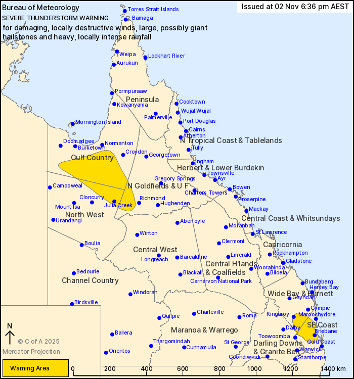
For people in parts of Gulf Country, Northern Goldfields and Upper
Flinders, North West, Wide Bay and Burnett, Southeast Coast and
Darling Downs and Granite Belt Forecast Districts.
Issued at 6:36 pm Sunday, 2 November 2025.
SEVERE THUNDERSTORMS WITH GIANT HAIL AND POSSIBLE INTENSE RAINFALL
THROUGH PARTS OF SOUTHEAST QUEENSLAND.
Weather Situation: Moisture and deep instability along and to the
east of a surface trough is promoting the development of severe
thunderstorm activity this afternoon.
Severe thunderstorms are likely to produce damaging winds over the
next several hours in parts of the Gulf Country, Northern
Goldfields and Upper Flinders and North West districts. Locations
which may be affected include Julia Creek, Kamilaroi Station,
Augustus Downs Station, Donors Hill Station, Gregory Downs Station,
Iffley and Cloney's Creek.
VERY DANGEROUS THUNDERSTORMS are likely to produce large, possibly
giant hailstones, damaging, locally destructive winds and heavy,
locally intense rainfall that may lead to dangerous and
life-threatening flash flooding over the next several hours in
parts of the Wide Bay and Burnett, Southeast Coast and Darling
Downs and Granite Belt districts. Locations which may be affected
include Brisbane, Kingaroy, Ipswich, Redcliffe, Lowood, Nanango,
Caboolture, Esk and Kilcoy.
Severe thunderstorms are no longer occurring in the Central
Highlands and Coalfields and Capricornia districts and the warning
for these districts is CANCELLED.
7 CM HAIL REPORTED AT YARRAMAN AT 5:40 PM.
8 CM HAIL REPORTED AT GOOGA CREEK AT 5:15PM
104 km/h wind gust was recorded at Cloncurry Airport at 03:23
pm.
02/Nov/2025 08:44 AM


