
Source: Bureau of Meteorology
For people in parts of Sydney and Gosford/Wyong areas.
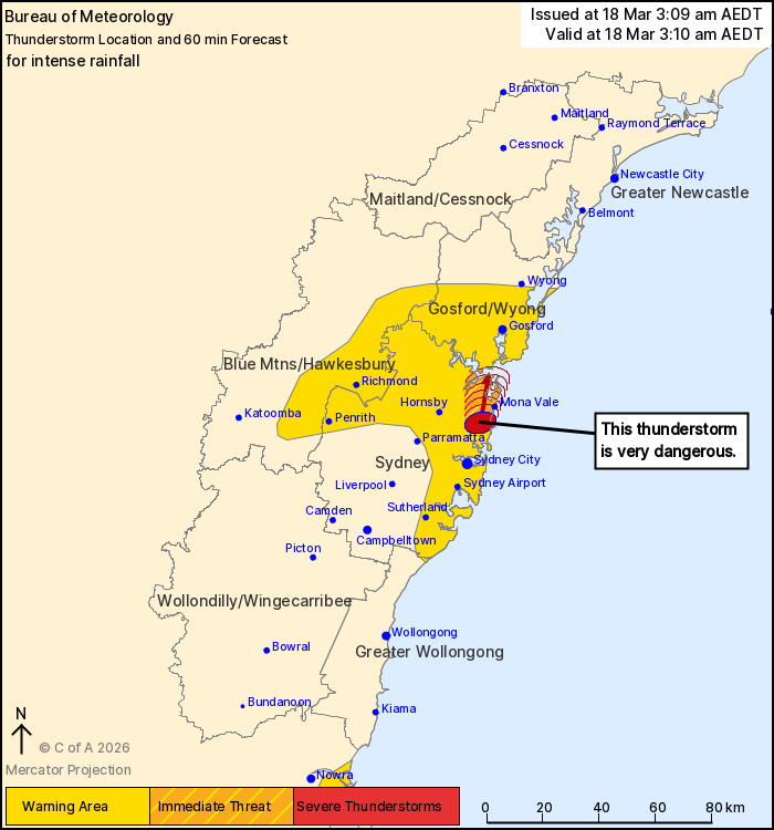
Issued at 3:09 am Wednesday, 18 March 2026.
Slow moving thunderstorms producing heavy, locally intense rain
along the central NSW coast.
A southerly change has been moving up the coast and triggering
heavy rainfall in a moist atmosphere. The heaviest rainfall is
occurring in northern Sydney.
The Bureau of Meteorology warns that, at 3:10 am, a VERY DANGEROUS
THUNDERSTORM likely to produce heavy, locally intense rainfall that
may lead to dangerous and life-threatening flash flooding was
detected near Dee Why and Collaroy. This thunderstorm is moving
towards the north. It is forecast to affect Mona Vale, Terrey Hills
and Avalon Beach by 3:40 am and Palm Beach by 4:10 am.
The State Emergency Service advises that people should:
* Keep clear of creeks and storm drains.
* Don't walk, ride your bike or drive through flood water.
* If you are trapped by flash flooding, seek refuge in the highest
available place and ring 000 if you need rescue.
* Stay indoors away from windows, and keep children and pets
indoors as well.
For emergency help in flood and storms, ring the SES on 132
500.
Stay updated on the Hazards Near Me NSW app or the ACT ESA website
(https://esa.act.gov.au).
17/Mar/2026 04:20 PM

