
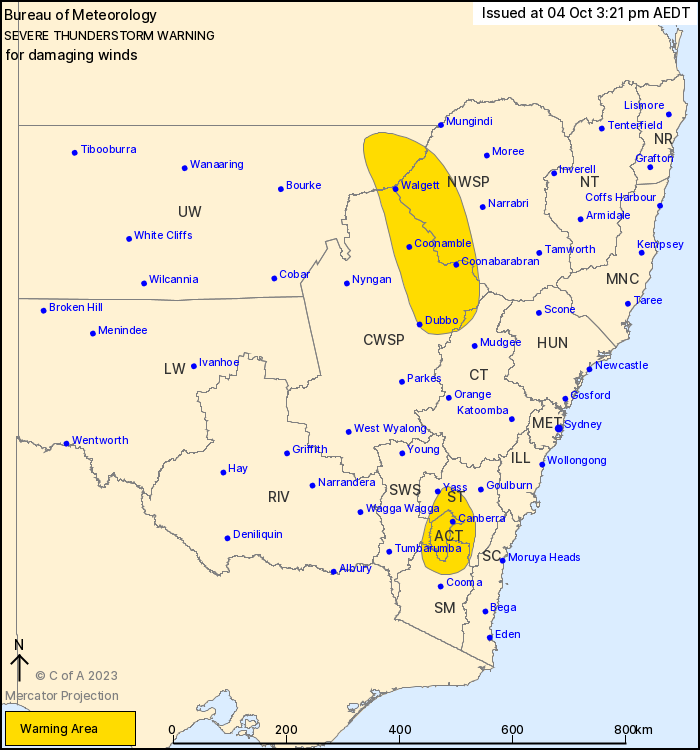
Source: Bureau of Meteorology
For people in Australian Capital Territory and parts of Southern
Tablelands, North West Slopes and Plains, Central West Slopes and
Plains, Upper Western, Snowy Mountains, Central Tablelands and
South West Slopes Forecast Districts.
Issued at 3:21 pm Wednesday, 4 October 2023.
Severe thunderstorms developing about the interior of the
state.
Weather Situation: A vigorous cold front and associated upper
trough will sweep across the state today, resulting in the
development of fast-moving severe thunderstorms capable of
producing damaging wind gusts.
Severe thunderstorms are likely to produce damaging winds in the
warning area over the next several hours. Locations which may be
affected include Canberra, Walgett, Dubbo, Coonabarabran, Coonamble
and Lightning Ridge.
The State Emergency Service advises that people should:
* Move your car under cover or away from trees.
* Secure or put away loose items around your house, yard and
balcony.
* Keep at least 8 metres away from fallen power lines or objects
that may be energised, such as fences.
* Report fallen power lines to either Ausgrid (131 388), Endeavour
Energy (131 003), Essential Energy (132 080) or Evoenergy (131 093)
as shown on your power bill.
* Trees that have been damaged by fire are likely to be more
unstable and more likely to fall.
* Unplug computers and appliances.
* Avoid using the phone during the storm.
* Stay indoors away from windows, and keep children and pets
indoors as well.
* Stay vigilant and monitor conditions. Note that the landscape
may have changed following bushfires.
* For emergency help in floods and storms, ring the SES (NSW and
ACT) on 132 500.
04/Oct/2023 04:28 AM


