
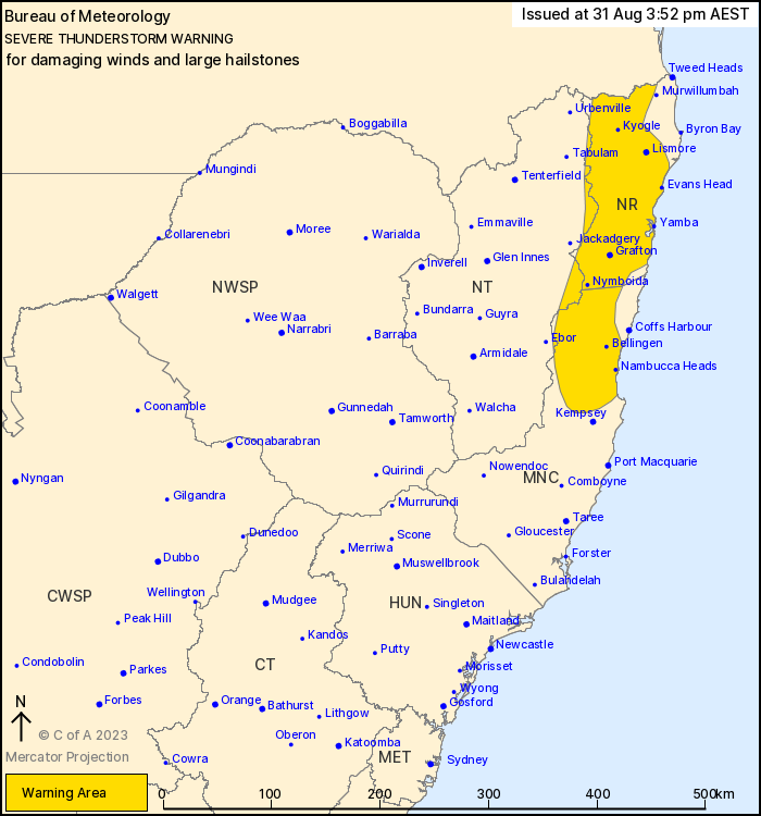
Source: Bureau of Meteorology
For people in Northern Rivers and parts of Mid North Coast and
Northern Tablelands Forecast Districts.
Issued at 3:52 pm Thursday, 31 August 2023.
Severe thunderstorms continuing over northeast New South
Wales.
Weather Situation: A humid and unstable airmass is combining with
a trough of low-pressure and seabreezes to produce severe
thunderstorms over northeast New South Wales this afternoon and
evening.
Severe thunderstorms are likely to produce damaging wind gusts,
large hailstones and accumulations of small hail in the warning
area over the next hour or two. Locations which may be affected
include Lismore, Grafton, Kyogle, Yamba, Maclean and Dorrigo.
Severe thunderstorms are no longer occurring in the Hunter
district and the warning for this district is CANCELLED.
The State Emergency Service advises that people should:
* Move your car under cover or away from trees.
* Secure or put away loose items around your house, yard and
balcony.
* Keep at least 8 metres away from fallen power lines or objects
that may be energised, such as fences.
* Report fallen power lines to either Ausgrid (131 388), Endeavour
Energy (131 003), Essential Energy (132 080) or Evoenergy (131 093)
as shown on your power bill.
* Trees that have been damaged by fire are likely to be more
unstable and more likely to fall.
* Unplug computers and appliances.
* Avoid using the phone during the storm.
* Stay indoors away from windows, and keep children and pets
indoors as well.
* Stay vigilant and monitor conditions. Note that the landscape
may have changed following bushfires.
* For emergency help in floods and storms, ring the SES (NSW and
ACT) on 132 500.
31/Aug/2023 06:09 AM


