
Source: Bureau of Meteorology
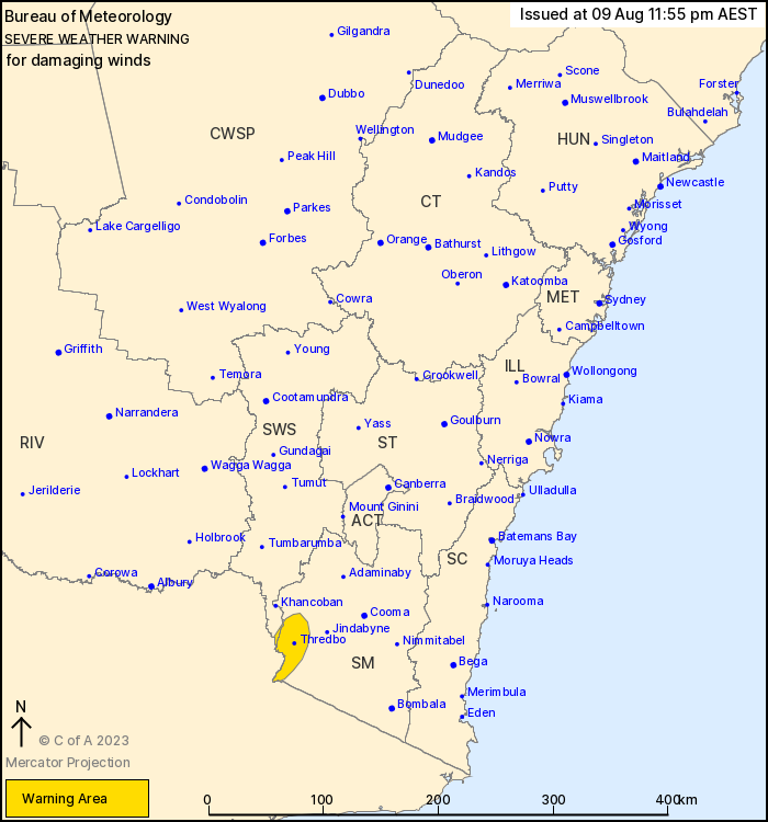
For people in parts of Snowy Mountains and South West Slopes
Forecast Districts.
Issued at 11:55 pm Wednesday, 9 August 2023.
DAMAGING northerly winds increasing tonight and early Thursday
morning ahead of an approaching cold front.
Weather Situation: A moderate cold front is approaching from the
west, bringing strong northerly winds and damaging wind
gusts.
DAMAGING northerly winds will persist this evening and during the
early hours of Thursday morning with gusts up to 90km/h ahead of
the cold front. Winds may reach and exceed 110km/h at more elevated
and exposed locations. The front will approach Thursday morning
when gusty showers may briefly increase wind strength. Winds will
ease as the front crosses southern New South Wales during Thursday
morning as winds shift southwesterly behind the front.
Locations which may be affected include Perisher Valley, Charlotte
Pass and Thredbo.
118 km/h wind gust recorded at Thredbo at 11:30pm.
The State Emergency Service advises that people should:
* Move vehicles under cover or away from trees.
* Secure or put away loose items around your house, yard and
balcony.
* Keep at least 8 metres away from fallen power lines or objects
that may be energised, such as fences.
* Trees that have been damaged by fire are likely to be more
unstable and more likely to fall.
* Report fallen power lines to either Ausgrid (131 388), Endeavour
Energy (131 003), Essential Energy (132 080) or Evoenergy (131 093)
as shown on your power bill.
* Stay vigilant and monitor conditions. Note that the landscape
may have changed following bushfires.
* For emergency help in floods and storms, ring your local SES
Unit on 132 500.
09/Aug/2023 02:06 PM


