
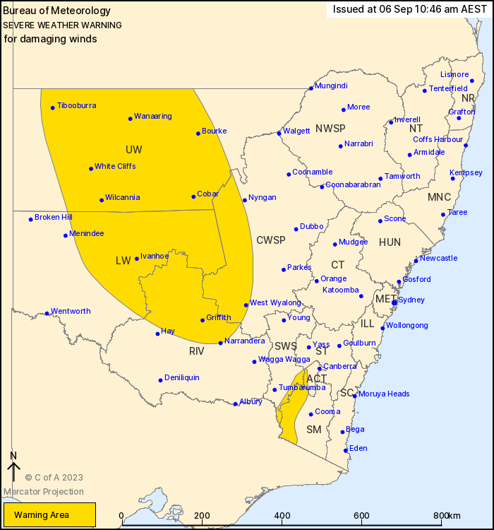
Source: Bureau of Meteorology
For people in Upper Western and parts of Central West Slopes and
Plains, South West Slopes, Riverina, Lower Western, Snowy
Mountains, Australian Capital Territory and Southern Tablelands
Forecast Districts.
Issued at 10:46 am Wednesday, 6 September 2023.
Damaging winds developing over the western inland and Alpine
region during Thursday.
Weather Situation: A vigorous cold front is forecast to enter
western NSW during Thursday morning, tracking eastwards across the
state during the day. Gusty north to northwesterly winds ahead of
this system and gusty thunderstorms will result in a damaging wind
risk across much of the state, with conditions easing as the front
tracks offshore early Friday afternoon.
Locally DAMAGING WINDS averaging between 60 to 70 km/h with peak
gusts of around 100 km/h are likely to develop over the western
inland from late Thursday morning, easing during the evening.
DAMAGING WINDS averaging between 80 to 90 km/h with DAMAGING WIND
GUSTS in excess of 125 km/h are likely to develop over alpine areas
above 1900 m during Thursday evening, easing Friday morning.
Locations which may be affected include West Wyalong, Griffith,
Tibooburra, Cobar, Bourke, Wilcannia, White Cliffs,
Wanaaring,Ivanhoe and Thredbo Top Station.
The State Emergency Service advises that people should:
* Move vehicles under cover or away from trees.
* Secure or put away loose items around your house, yard and
balcony.
* Keep at least 8 metres away from fallen power lines or objects
that may be energised, such as fences.
* Trees that have been damaged by fire are likely to be more
unstable and more likely to fall.
* Report fallen power lines to either Ausgrid (131 388), Endeavour
Energy (131 003), Essential Energy (132 080) or Evoenergy (131 093)
as shown on your power bill.
* Stay vigilant and monitor conditions. Note that the landscape
may have changed following bushfires.
* For emergency help in floods and storms, ring your local SES
Unit on 132 500.
06/Sep/2023 01:03 AM


