
Source: Bureau of Meteorology
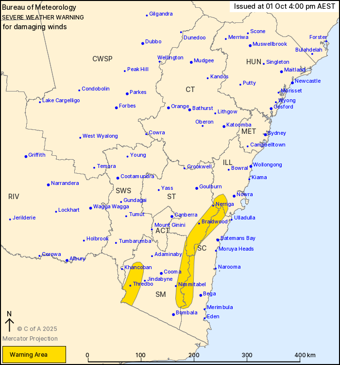
For people in parts of Illawarra, South Coast, Southern Tablelands
and Snowy Mountains Forecast Districts.
Issued at 4:00 pm Wednesday, 1 October 2025.
Damaging winds redeveloping over alpine areas this evening,
extending over the southern Great Diving Range from early Thursday
morning.
Weather Situation: Damaging west to northwesterly winds are
expected to develop over elevated parts of the southeast of the
state from Wednesday evening as a cold front approaches from the
west. Winds are forecast to ease for a period from late Thursday
morning, redeveloping later in the afternoon.
For ALPINE PEAKS above 1900 metres: DAMAGING WINDS averaging 80 to
90 km/h with peak gusts around 120 km/h are likely from this
evening, easing during Thursday morning. DAMAGING WINDS are
forecast to redevelop during Thursday afternoon.
For the SOUTHERN GREAT DIVING RANGE: Strong winds averaging 50 to
60 km/h with DAMAGING WIND GUSTS of around 90 km/h are possible
from early Thursday morning, easing by late Thursday morning.
DAMAGING WIND GUSTS are forecast to redevelop during Thursday
afternoon.
Locations which may be affected include Braidwood, Nerriga,
Thredbo Top Station, Araluen.
The State Emergency Service advises that people should:
* Move vehicles under cover or away from trees.
* Secure or put away loose items around your house, yard and
balcony.
* Keep at least 8 metres away from fallen power lines or objects
that may be energised, such as fences.
* Trees that have been damaged by fire are likely to be more
unstable and more likely to fall.
* Report fallen power lines to either Ausgrid (131 388), Endeavour
Energy (131 003), Essential Energy (132 080) or Evoenergy (131 093)
as shown on your power bill.
* Stay vigilant and monitor conditions. Note that the landscape
may have changed following bushfires.
* For emergency help in floods and storms, ring your local SES
Unit on 132 500.
01/Oct/2025 06:08 AM


