
Source: Bureau of Meteorology
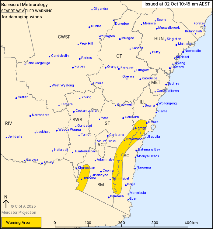
For people in parts of Illawarra, South Coast, Southern Tablelands
and Snowy Mountains Forecast Districts.
Issued at 10:45 am Thursday, 2 October 2025.
Damaging winds over alpine areas and the southern Great Dividing
Range.
Weather Situation: Damaging west to northwesterly winds are
expected over elevated parts of the southeast of the state during
Thursday associated with the passage of a cold front. Winds may
ease for a period during the day, before redeveloping during the
afternoon with the secondary passage of a trough.
For ALPINE PEAKS above 1900 metres: DAMAGING WINDS averaging 80 to
90 km/h with peak gusts around 100 km/h are expected to redevelop
during Thursday afternoon, easing Friday morning.
For the SOUTHERN GREAT DIVIDING RANGE: Strong winds averaging 50
to 60 km/h with DAMAGING WIND GUSTS of around 90 km/h are possible
during Thursday, easing by late Thursday evening.
Locations which may be affected include Nowra, Braidwood, Nerriga,
Thredbo Top Station, Araluen.
The State Emergency Service advises that people should:
* Move vehicles under cover or away from trees.
* Secure or put away loose items around your house, yard and
balcony.
* Keep at least 8 metres away from fallen power lines or objects
that may be energised, such as fences.
* Trees that have been damaged by fire are likely to be more
unstable and more likely to fall.
* Report fallen power lines to either Ausgrid (131 388), Endeavour
Energy (131 003), Essential Energy (132 080) or Evoenergy (131 093)
as shown on your power bill.
* Stay vigilant and monitor conditions. Note that the landscape
may have changed following bushfires.
* For emergency help in floods and storms, ring your local SES
Unit on 132 500.
02/Oct/2025 12:54 AM


