
Source: Bureau of Meteorology
For people in parts of South Coast, Southern Tablelands, Snowy
Mountains, Australian Capital Territory and South West Slopes
Forecast Districts.
Issued at 11:29 am Thursday, 9 October 2025.
Damaging winds expected to develop over the southeast ranges on
Friday morning.
Weather Situation: Vigorous west to northwesterly flow is expected
to develop over the southeast ranges on Friday morning ahead of a
strong frontal system passing over southeastern Australia.
Strong west to northwesterly winds with peak gusts around 90 km/h
are likely to develop during Friday morning and continue into
Friday afternoon.
For ALPINE AREAS above 1900 metres: DAMAGING WINDS averaging 80 to
90 km/h are likely to develop from the early hours of Friday
morning into the afternoon.
Winds are forecast to ease below warning thresholds from Friday
late afternoon into the evening.
Winds have eased around the Illawarra and coastal parts of the
South Coast district this morning, and the warning for this area is
cancelled.
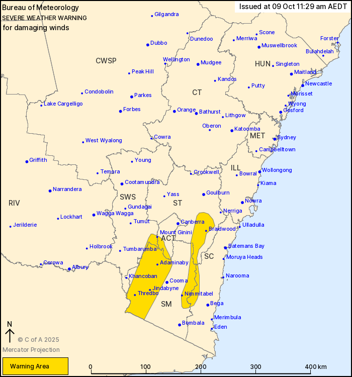
Locations which may be affected include Braidwood, Mount Ginini,
Jindabyne, Thredbo, Adaminaby and Nimmitabel.
Severe weather is no longer occurring in the Illawarra district
and the warning for this district is CANCELLED.
The State Emergency Service advises that people should:
* Move vehicles under cover or away from trees.
* Secure or put away loose items around your house, yard and
balcony.
* Keep at least 8 metres away from fallen power lines or objects
that may be energised, such as fences.
* Trees that have been damaged by fire are likely to be more
unstable and more likely to fall.
* Report fallen power lines to either Ausgrid (131 388), Endeavour
Energy (131 003), Essential Energy (132 080) or Evoenergy (131 093)
as shown on your power bill.
* Stay vigilant and monitor conditions. Note that the landscape
may have changed following bushfires.
* For emergency help in floods and storms, ring your local SES
Unit on 132 500.
09/Oct/2025 12:37 AM


