
Source: Bureau of Meteorology
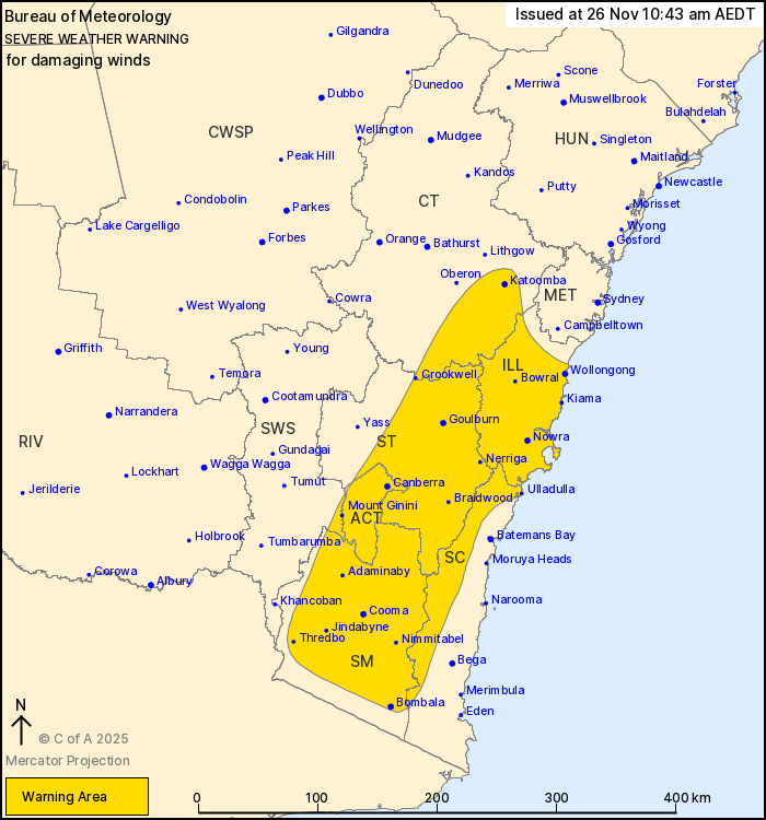
For people in Illawarra, Southern Tablelands, Snowy Mountains,
Australian Capital Territory and parts of South Coast, Central
Tablelands and South West Slopes Forecast Districts.
Issued at 10:43 am Wednesday, 26 November 2025.
Damaging wind gusts developing today across the southeast,
including Wollongong and Canberra.
Weather Situation: A front crosses central New South Wales today,
bringing increased west to northwesterly flow and damaging wind
gusts to parts of the southeast. Isolated thunderstorms this
morning and early afternoon in the central east also pose a wind
gust risk.
DAMAGING WEST TO NORTHWESTERLY WIND GUSTS in excess of 90 km/h are
developing across the warning area this morning, continuing through
the afternoon, then easing during this evening.
Locations which may be affected include Wollongong, Nowra,
Canberra, Goulburn, Bowral and Katoomba.
The State Emergency Service advises that people should:
* Move vehicles under cover or away from trees.
* Secure or put away loose items around your house, yard and
balcony.
* Keep at least 8 metres away from fallen power lines or objects
that may be energised, such as fences.
* Trees that have been damaged by fire are likely to be more
unstable and more likely to fall.
* Report fallen power lines to either Ausgrid (131 388), Endeavour
Energy (131 003), Essential Energy (132 080) or Evoenergy (131 093)
as shown on your power bill.
* Stay vigilant and monitor conditions. Note that the landscape
may have changed following bushfires.
* For emergency help in floods and storms, ring your local SES
Unit on 132 500.
25/Nov/2025 11:49 PM

