
Source: Bureau of Meteorology
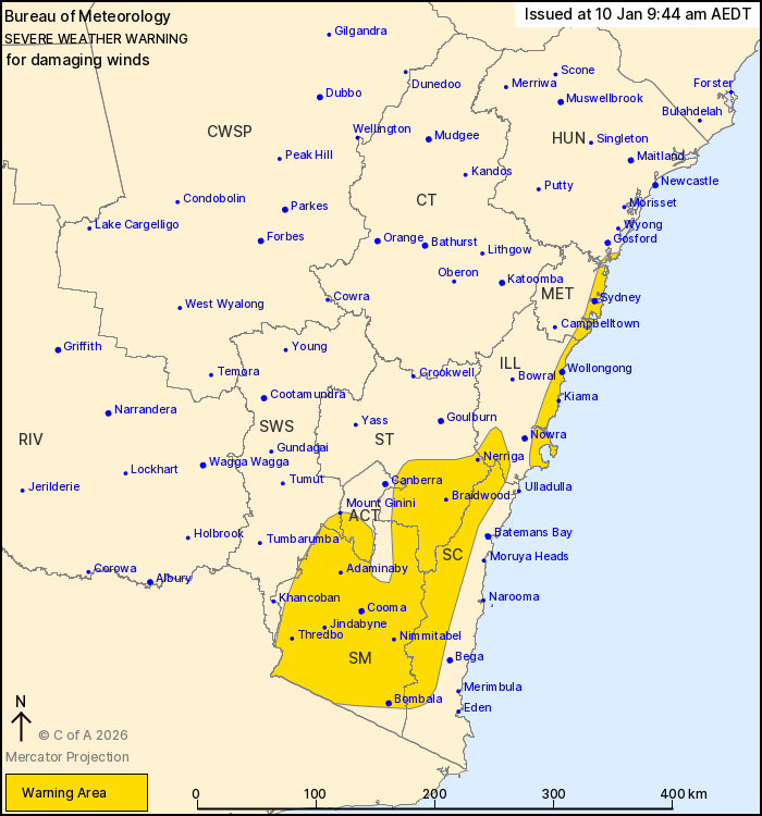
For people in Snowy Mountains and parts of Metropolitan,
Illawarra, South Coast, Southern Tablelands, Australian Capital
Territory, Hunter and South West Slopes Forecast Districts.
Issued at 9:44 am Saturday, 10 January 2026.
Damaging winds about the southeast today, shifting to the
Illawarra and Sydney coasts this evening with a southerly
buster.
Weather Situation: West to northwesterly winds have strengthened
through the inland southeast ahead of a trough passage today. A
southerly change is currently positioned about the far south coast,
which is expected to accelerate about the Illawarra and Sydney
coasts this evening bringing damaging southerly winds.
For the ILLAWARRA, SYDNEY and SOUTHERN CENTRAL COAST: DAMAGING
SOUTHERLY WINDS averaging 55 to 65 km/h with peak gusts around 100
km/h are likely from early this evening, expected to ease below
warning thresholds in the late evening.
For the REMAINDER OF THE WARNING AREA: Strong west to
northwesterly winds averaging 50 to 60 km/h with peaks gusts around
100 km/h are expected today, easing below warning thresholds around
mid-afternoon.
Locations which may be affected include Sydney, Wollongong, Cooma,
Braidwood, Bombala, Kiama, Nerriga, Mount Ginini, Jindabyne,
Thredbo, Adaminaby and Nimmitabel.
Sustained winds of 83 km/h were observed at Thredbo Top Station at
2:14 am.
The State Emergency Service advises that people should:
* Park your car under secure cover and away from trees, powerlines
and drains.
* Secure or put away loose items around your house, yard and
balcony.
* Keep at least 8 metres away from fallen power lines or objects
that may be energised, such as fences.
* Report fallen power lines to either Ausgrid (131 388), Endeavour
Energy (131 003), Essential Energy (132 080) or Evoenergy (131 093)
as shown on your power bill.
For emergency help in flood and storms, ring the SES on 132
500.
Stay updated on the Hazards Near Me NSW app or the ACT ESA website
(https://esa.act.gov.au).
09/Jan/2026 11:25 PM


