
Source: Bureau of Meteorology
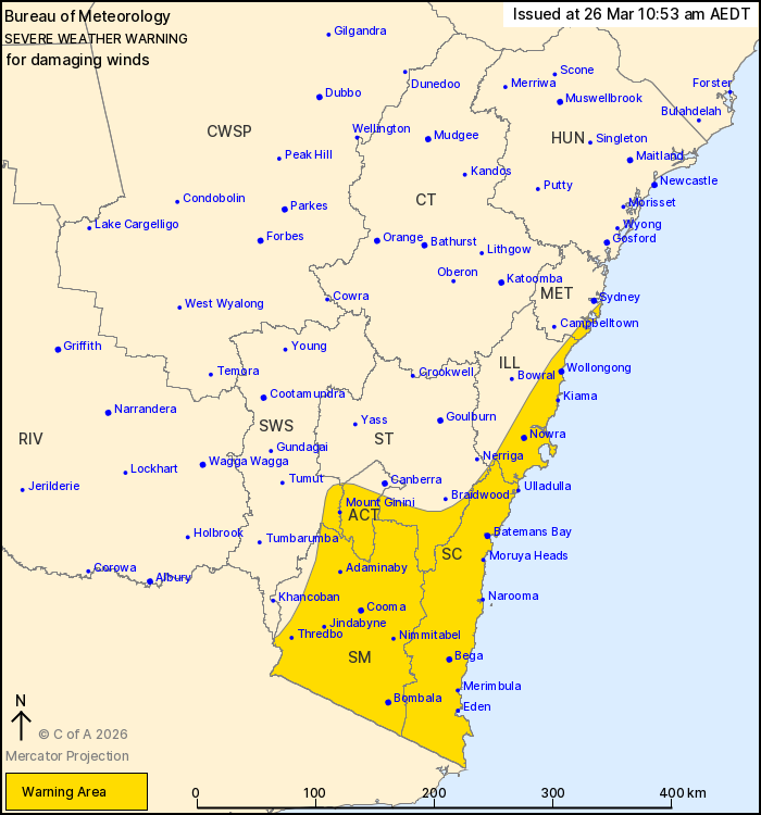
For people in South Coast, Snowy Mountains, Australian Capital
Territory and parts of Metropolitan, Illawarra, Southern Tablelands
and South West Slopes Forecast Districts.
Issued at 10:53 am Thursday, 26 March 2026.
Damaging winds developing over southeastern NSW including the ACT
on Friday.
Weather Situation: A vigorous coastal low will develop offshore of
the southern NSW coast on Friday, bringing damaging southerly winds
to parts of southeastern NSW including the ACT. Conditions will
begin to ease later on Friday and into early Saturday as the low
moves further offshore.
DAMAGING SOUTHERLY WIND GUSTS with peak gusts of around 100 km/h
are likely to develop over parts of the Snowy Mountains and South
Coast from Friday morning, before spreading northwards into the
remainder of the warning area on Friday afternoon. Wind gusts along
the coastal fringe of the South Coast and Illawarra may reach 110
km/h during Friday afternoon.
DAMAGING WINDS averaging 80 to 90 km/h are possible over the
alpine areas above 1900 m on Friday morning and afternoon.
Conditions are expected to ease below warning thresholds
throughout by late Friday evening or early Saturday morning.
Locations which may be affected include parts of the Sydney coast,
Wollongong, Nowra, Batemans Bay, Eden, Cooma and Bega.
The State Emergency Service advises that people should:
* Park your car under secure cover and away from trees, powerlines
and drains.
* Secure or put away loose items around your house, yard and
balcony.
* Keep at least 8 metres away from fallen power lines or objects
that may be energised, such as fences.
* Report fallen power lines to either Ausgrid (131 388), Endeavour
Energy (131 003), Essential Energy (132 080) or Evoenergy (131 093)
as shown on your power bill.
For emergency help in flood and storms, ring the SES on 132
500.
Stay updated on the Hazards Near Me NSW app or the ACT ESA website
(https://esa.act.gov.au).
26/Mar/2026 12:01 AM

