
Source: Bureau of Meteorology
for HEAVY, LOCALLY INTENSE RAINFALL
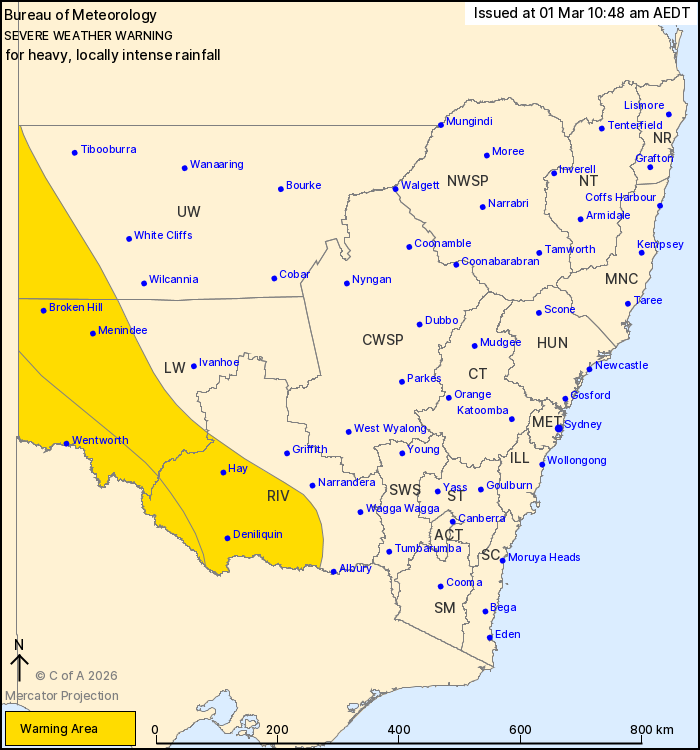
For people in parts of Riverina, Lower Western and Upper Western
Forecast Districts.
Issued at 10:48 am Sunday, 1 March 2026.
HEAVY, LOCALLY INTENSE RAINFALL POSSIBLE IN THE SOUTH WEST, MOST
LIKELY FROM TONIGHT
Weather Situation: Tropical humidity is expected to continue to
increase on the eastern flank of a low in South Australia,
persisting a broad region of rain with isolated thunderstorms. A
trough is expected to push into the far southwest of the state
overnight tonight, increasing rain and thunderstorm activity and
the risk of heavy to locally intense falls.
HEAVY RAINFALL which may lead to FLASH FLOODING is possible for
southwestern parts of the Upper Western, Lower Western and Riverina
forecast districts today, with the risk becoming likely overnight
tonight. Six-hourly rainfall totals between 40 to 70 mm are
likely.
Locally, INTENSE RAINFALL which may lead to DANGEROUS AND
LIFE-THREATENING FLASH FLOODING is possible throughout the warning
area with thunderstorms, however is most likely about the far
southern Lower Western and southwestern Riverina from later
tonight. Six-hourly rainfall totals between 70 to 100 mm are
possible.
Locations which may be affected include Deniliquin, Broken Hill,
Hay, Wentworth, Menindee and Balranald.
Flood Watches and Warnings are current for the area. Please refer
to https://www.bom.gov.au/weather-and-climate/warnings-and-alerts/
for more information.
The State Emergency Service advises that people should:
* Don't drive, ride or walk through flood water.
* Keep clear of creeks and storm drains.
* If you are trapped by flash flooding, seek refuge in the highest
available place and ring 000 if you need rescue.
For emergency help in flood and storms, ring the SES on 132
500.
Stay updated on the Hazards Near Me NSW app or the ACT ESA website
(https://esa.act.gov.au).
01/Mar/2026 12:01 AM

