
Source: Bureau of Meteorology
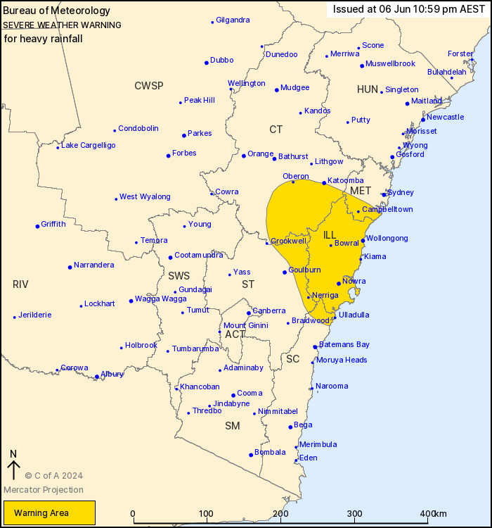
For people in Illawarra and parts of Metropolitan, South Coast,
Central Tablelands and Southern Tablelands Forecast
Districts.
Issued at 10:59 pm Thursday, 6 June 2024.
Heavy rainfall to continue over the Illawarra and surrounds
tonight, easing later on Friday.
Weather Situation: A surface trough extending through northern
parts of the Illawarra will continue to draw a humid southeasterly
airmass to its south, currently generating areas of heavy rainfall
about the northern parts of the warning area. This trough and the
associated southeasterly flow is expected to hover about the
central and northern Illawarra through Friday morning, before
tracking southward and weakening during Friday afternoon and
evening.
HEAVY RAINFALL which may lead to FLASH FLOODING is forecast for
the Illawarra and parts of the South Coast, Southern and Central
Tablelands, and Metropolitan districts for the remainder of the day
and through Friday afternoon. Scattered six-hourly rainfall totals
between 50 and 100 mm are likely with isolated totals around 150 mm
possible. Scattered 24-hourly rainfall totals between 100 and 150
mm are also likely with isolated totals around 250 mm
possible.
The area of heaviest rainfall has recently shifted north along the
coast between Kiama and Wollongong, with further northward movement
expected throughout the night. Heavy rainfall may redevelop again
in more southern parts of the warning area during Friday morning,
as the trough retrogrades southwards. Conditions are expected to
ease throughout during Friday afternoon and evening.
Flood Watch is current for parts of the Central Coast, Sydney
Metropolitan Area, Illawarra and South Coast while various Flood
Warnings are also current. Please refer to
http://www.bom.gov.au/nsw/warnings/
Locations which may be affected include Wollongong, Nowra, Bowral,
Campbelltown, Ulladulla, Jenolan Caves, Oberon, Taralga and
Nerriga.
Significant rainfall observations from 9:00 am to 11:00 pm AEST
Thursday:
136 mm at Cringila in the 6 hours to 10:51 pm,
132 mm at Nowra (Tomerong Ck) in the 6 hours to 12:36 pm,
106 mm at Yalwal in the 3 hours to 2:38 pm.
Significant rainfall observations to 9:00 am AEST Thursday:
99 mm at Vincentia in the 3 hours to 8:10 am, 176 mm in 24
hours;
87 mm at Nowra (Tomerong Creek) in the 3 hours to 8:15 am, 152 mm
in 24 hours;
100 mm at Currarong in the 6 hours to 2:30 am, 188 mm in 24
hours.
The State Emergency Service advises that people should:
* Don't drive, ride or walk through flood water.
* Keep clear of creeks and storm drains.
* If you are trapped by flash flooding, seek refuge in the highest
available place and ring 000 if you need rescue.
* Be aware that run-off from rainfall in fire affected areas may
behave differently and be more rapid. It may also contain debris
such as ash, soil, trees and rocks.
* After bushfires, heavy rain and the loss of foliage can make the
ground soft and heavy, leading to a greater chance of
landslides.
* Stay vigilant and monitor conditions. Note that the landscape
may have changed following bushfires.
* For emergency help in floods and storms, ring your local SES
Unit on 132 500.
06/Jun/2024 01:06 PM

