
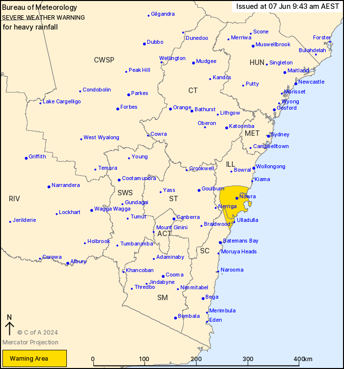
Source: Bureau of Meteorology
For people in parts of Illawarra and South Coast Forecast
Districts.
Issued at 9:43 am Friday, 7 June 2024.
Heavy rainfall continuing over the southern Illawarra and
surround, easing by this afternoon.
A surface trough near the coast with moist onshore flow has been
generating areas of heavy rainfall. The trough is stalling with
rain areas contracting to Illawarra and South Coast, before
weakening and easing rainfall this afternoon.
HEAVY RAINFALL which may lead to FLASH FLOODING is likely to
continue for southern parts of the Illawarra, parts of the South
Coast, during this morning. Scattered six-hourly rainfall totals
between 40 and 60 mm are likely with isolated totals around 100 mm
possible.
Heavy rainfall likely to ease during the afternoon.
Flood Watch is current for parts of the Central Coast, Sydney
Metropolitan Area, Illawarra and South Coast while various Flood
Warnings are also current. Please refer to
http://www.bom.gov.au/nsw/warnings/
Locations which may be affected include Nowra, Huskisson and
Ulladulla.
Significant rainfall observations to 9:00 am AEST Friday:
214 mm at Cringila in 24 hours.
204 mm at Port Kembla in 24 hours.
156 mm at Wollongong in 24 hours.
151 mm at High Range in 24 hours.
134 mm at Kiama in 24 hours.
The State Emergency Service advises that people should:
* Don't drive, ride or walk through flood water.
* Keep clear of creeks and storm drains.
* If you are trapped by flash flooding, seek refuge in the highest
available place and ring 000 if you need rescue.
* Be aware that run-off from rainfall in fire affected areas may
behave differently and be more rapid. It may also contain debris
such as ash, soil, trees and rocks.
* After bushfires, heavy rain and the loss of foliage can make the
ground soft and heavy, leading to a greater chance of
landslides.
* Stay vigilant and monitor conditions. Note that the landscape
may have changed following bushfires.
* For emergency help in floods and storms, ring your local SES
Unit on 132 500.
06/Jun/2024 11:47 PM

