
Source: Bureau of Meteorology
Issued at 10:57 am Thursday, 22 May 2025.
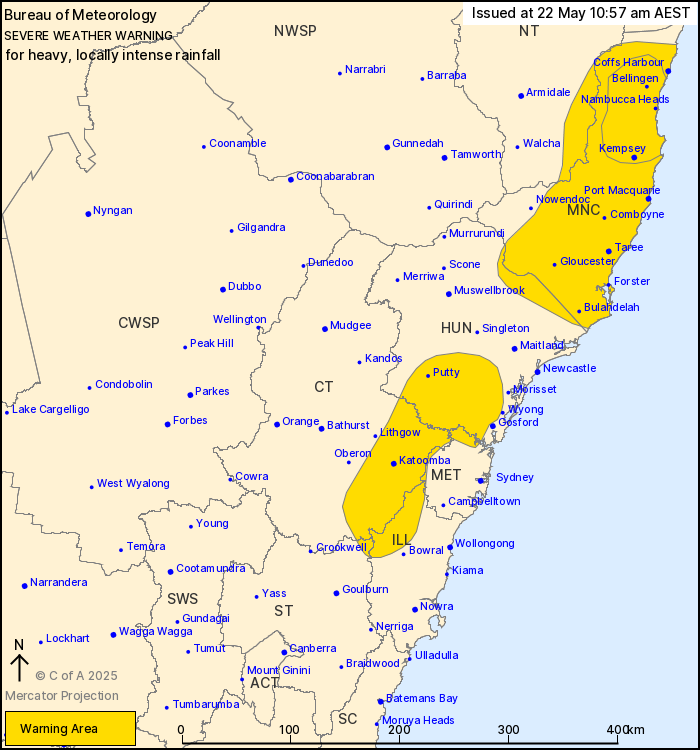
HEAVY TO LOCALLY INTENSE RAINFALL CONTINUING ABOUT THE MID NORTH
COAST. HEAVY FALLS DEVELOPING ABOUT THE SOUTHERN HUNTER, BLUE
MOUNTAINS AND SOUTHERN HIGHLANDS TONIGHT.
Weather Situation: A coastal trough is situated in the vicinity of
Coffs Harbour this morning and is expected to drift steadily south
today. A persistent and very moist onshore flow to the south of the
trough continues to cause widespread areas of rain across the Mid
North Coast, with heavy showers and isolated thunderstorms.
Conditions across the Mid North Coast are expected to ease by
Thursday night, with the focus of the rainfall shifting to parts of
the Southern Highlands, Blue Mountains and southern Hunter.
For the MID NORTH COAST and adjacent NORTHERN TABLELANDS AND
HUNTER: Moderate rainfall with isolated areas of HEAVY RAINFALL
leading to FLASH FLOODING is forecast to continue until late
tonight. Six-hourly rainfall totals between 60 and 100 mm and
12-hourly totals between 90 and 120 mm are likely.
Locally INTENSE RAINFALL which may lead to DANGEROUS AND
LIFE-THREATENING FLASH FLOODING is also possible for parts of the
Mid North Coast between Kempsey and Dorrigo, mainly about elevated
areas. Six-hourly rainfall totals between 100 and 150 mm are
possible with 12-hourly totals reaching between 150 and 200
mm.
HEAVY RAINFALL is expected to ease about the Mid North Coast by
midnight.
For parts of the SOUTHERN HIGHLANDS, BLUE MOUNTAINS AND SOUTHERN
HUNTER: Moderate rainfall during today is expected to increase
overnight, with areas of HEAVY RAINFALL leading to FLASH FLOODING
possible from early Friday morning until Friday evening. Six-hourly
rainfall totals of 60 to 90 mm are possible with 24-hourly totals
between 80 and 130 mm.
A Flood Watch and various Flood Warnings are current for multiple
catchments. Please refer to
http://www.bom.gov.au/nsw/warnings/.
Locations which may be affected include Coffs Harbour, Port
Macquarie, Taree, Katoomba, Sawtell and Dorrigo.
Severe weather is no longer occurring in the Northern Rivers and
North West Slopes and Plains districts and the warning for these
districts is CANCELLED.
Significant rainfall observations in the 24 hours to 9:00 am
Thursday morning include:
336 mm at Bellingen
323 mm at Moparrabah
242 mm at Englands Road (Coffs Harbour)
240 mm at Kooroowi
200 mm at Woolgoolga Dam
169 mm at Kempsey Airport
160 mm at Belleview Park (Dorrigo)
The State Emergency Service advises that people should:
* Don't drive, ride or walk through flood water.
* Keep clear of creeks and storm drains.
* If you are trapped by flash flooding, seek refuge in the highest
available place and ring 000 if you need rescue.
* Be aware that run-off from rainfall in fire affected areas may
behave differently and be more rapid. It may also contain debris
such as ash, soil, trees and rocks.
* After bushfires, heavy rain and the loss of foliage can make the
ground soft and heavy, leading to a greater chance of
landslides.
* Stay vigilant and monitor conditions. Note that the landscape
may have changed following bushfires.
* For emergency help in floods and storms, ring your local SES
Unit on 132 500.
22/May/2025 01:03 AM

