
Source: Bureau of Meteorology
Issued at 1:02 pm ACST on Sunday 1 March 2026
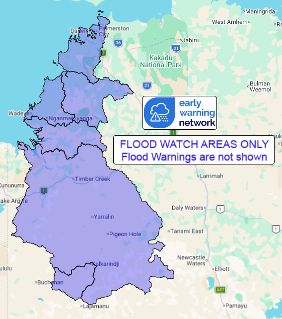
Flood Watch Number: 3
FLOODING POSSIBLE IN PARTS OF THE BONAPARTE AND NORTH WEST COASTAL
RIVERS FROM SUNDAY
A monsoon trough is developing across northern Australia, with a
tropical low (30U) developing on Monday, inland of the Joseph
Bonaparte Gulf, then moving slowly towards the west coast.
Catchments in the flood watch area are wet from recent rainfall.
Showers and thunderstorms will be more frequent about the trough,
with some heavy falls possible.
Rainfall may cause significant water level rises in rivers and
creeks and prolonged overland flooding and ponding from Sunday and
roads may become impassable. Some communities and homesteads may
become isolated. Check road conditions before travelling.
Catchments likely to be affected include:
Upper Victoria River
Victoria River below Kalkarindji
Fitzmaurice River
Moyle River
Lower Daly River(Localised flooding)
Finniss River
For the latest flood and weather warnings see
www.bom.gov.au/weather-and-climate/warnings-and-alerts
For the latest rainfall and river level information see
www.bom.gov.au/australia/flood
Safety Advice:
- Don't drive, walk, swim or play in floodwater because it is
dangerous.
- Stay away from flooded drains, rivers, streams and
waterways.
- Obey road closure signs. Plan ahead so you don't drive on
flooded roads.
- Check the ABC and local media for updates. The situation can
change quickly, so stay informed.
- For local emergency management warnings and advice visit
www.securent.nt.gov.au.
For emergency assistance call SES on telephone number 132 500. In
life-threatening emergencies, call 000 (triple zero)
immediately.
Rainfall and River
Conditions Map
01/Mar/2026 04:03 AM

