
Source: Bureau of Meteorology
TROPICAL CYCLONE ADVICE NUMBER 32
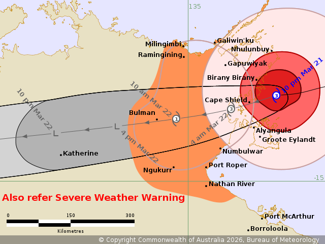
Issued at 10:23 pm ACST on Saturday 21 March 2026
Headline:
Severe Tropical Cyclone Narelle beginning to impact the eastern
Top End between Nhulunbuy and Groote Eylandt. To move west across
the Northern Territory on Sunday.
Areas Affected:
Warning Zone
Milingimbi to Nathan River, including Nhulunbuy, Galiwin'ku,
Numbulwar, Alyangula, Gapuwiyak, Bulman, and Ngukurr.
Watch Zone
King George River Mouth to WA/NT Border.
Cancelled Zone
None.
Details of Severe Tropical Cyclone Narelle 34U at 9:30 pm
ACST:
Intensity: Category 3, sustained winds near the centre of 130
kilometres per hour with wind gusts to 185 kilometres per
hour.
Location: within 30 kilometres of 13.2 degrees South 136.9 degrees
East, estimated to be 105 kilometres south of Nhulunbuy and 95
kilometres northeast of Alyangula.
Movement: west at 19 kilometres per hour.
Severe Tropical Cyclone Narelle is impacting coastal areas of the
eastern Top End with a coastal crossing early Sunday morning
between Birany Birany and Numbulwar. Narelle will then track across
the Top End on Sunday and Monday as a tropical low and a Severe
Weather Warning is current for heavy, locally intense rainfall and
damaging winds.
During Monday, Narelle is expected to move over the Joseph
Bonaparte Gulf and gales are forecast to redevelop to the north of
the centre. There is a Moderate chance that Narelle redevelops into
a tropical cyclone while in the Joseph Bonaparte Gulf near the
NT/WA Border.
Hazards:
VERY DESTRUCTIVE WINDS with gusts to 185 km/h are forecast to
develop in coastal areas between about Birany Birany and Numbulwar,
including Groote Eylandt, overnight into Sunday as Narelle makes
landfall.
DESTRUCTIVE WIND GUSTS to 160 km/h are expected between Nhulunbuy
and Numbulwar, including Groote Eylandt overnight into
Sunday.
GALES with DAMAGING WIND GUSTS to 120 km/h are developing in
coastal and adjacent inland areas between Cape Wessel and Nathan
River, including Nhulunbuy and Galiwin'ku, and are likely to
continue overnight into Sunday. These GALES may extend west to
Milingimbi, Ramingining, Bulman, and Ngukurr during Sunday
morning.
HEAVY RAINFALL which may lead to FLASH FLOODING is developing
about coastal and adjacent inland areas over the eastern Top End
between Milingimbi and Nathan River, and is forecast to extend
further inland during Sunday. LOCALLY INTENSE RAINFALL leading to
DANGEROUS AND LIFE-THREATENING FLASH FLOODING is likely over the
eastern Top End between Birany Birany and Numbulwar, including
Groote Eylandt overnight, extending inland towards Bulman on
Sunday.
Tides will be higher than normal between Milingimbi and Nathan
River tonight and Sunday. LARGE WAVES may produce MINOR FLOODING of
low-lying coastal areas. A DANGEROUS STORM TIDE between Birany
Birany and Port Roper, including Groote Eylandt, is possible as the
cyclone centre crosses the coast with DAMAGING WAVES and DANGEROUS
FLOODING.
Western Australia:
GALES with DAMAGING WIND GUSTS to 90 km/h are possible between
King George River Mouth and the WA/NT border during Monday.
HEAVY RAINFALL which may lead to FLASH FLOODING is possible for
the north Kimberley during Monday.
Recommended Action:
NTES advises:
People between Nhulunbuy and Numbulwar, including Groote Eylandt
(Alyangula), and Gapuwiyak, should remain inside until the cyclone
has passed and listen to the next advice at 1.30 am.
- Do not venture outside if you find yourself in the eye of the
cyclone - very destructive winds from a different direction could
resume at any time
- Heed the advice and follow the instructions of Emergency
Services personnel and local authorities.
People in remaining areas between Milingimbi and Nathan River,
including Numbulwar, Bulman, and Ngukurr, should take precautions
and listen to the next advice at 1:30 am.
- Outside property, including boats, playground equipment, chairs
and tables should be secured.
- For cyclone preparedness and safety advice, visit the Secure NT
website at https://securent.nt.gov.au
- For emergency assistance call the Northern Territory Emergency
Service (NTES) on 132 500 (for assistance with storm damage, rising
flood water, fallen trees on buildings or roof damage).
DFES advises:
Ensure you know what to do in a cyclone. For the latest DFES
community alerts and warnings visit www.emergency.wa.gov.au or
download the Emergency WA app.
Current
Tropical Cyclones
21/Mar/2026 12:59 PM

