
Source: Bureau of Meteorology
Issued at 4:43 pm EST on Friday 20 March 2026
Headline:
Tropical Cyclone Narelle at category 2 strength moving west and
impacting Aurukun.
Areas Affected:
Warning Zone
Queensland: Western Cape York Peninsula between Mapoon and
Pormpuraaw, including Weipa, Aurukun, and adjacent inland
areas.
Northern Territory: Nhulunbuy to Port McArthur, including
Borroloola, Numbulwar, Alyangula, and Gapuwiyak.
Watch Zone
Northern Territory: Extending west to include Ramingining, Bulman,
and Ngukurr.
Cancelled Zone
Eastern Cape York Peninsula including Lockhart River and
Coen.
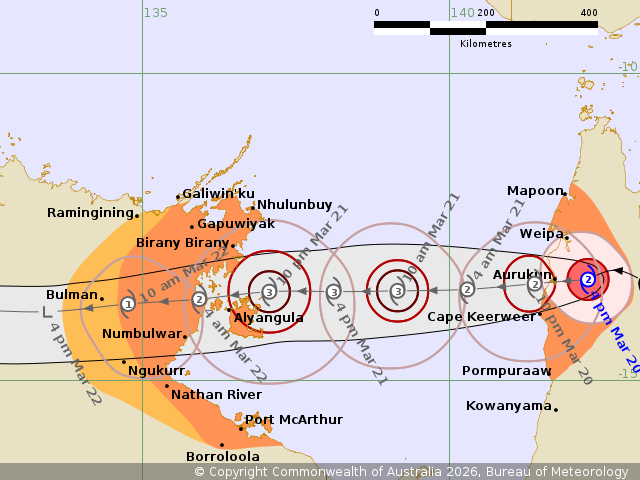
Details of Tropical Cyclone Narelle 34U at 4:00 pm AEST:
Intensity: Category 2, sustained winds near the centre of 100
kilometres per hour with wind gusts to 140 kilometres per
hour.
Location: within 30 kilometres of 13.3 degrees South 142.2 degrees
East, estimated to be 55 kilometres east of Aurukun and 630
kilometres east of Alyangula.
Movement: west at 18 kilometres per hour.
Tropical Cyclone Narelle is moving westwards across western Cape
York Peninsula towards Aurukun, where impacts are expected over the
next few hours. Narelle has continued to weaken, though currently
remains a category 2 system.
Narelle will continue to move west into the Gulf of Carpentaria
tonight, where it is expected to strengthen again to a severe
tropical cyclone before impacting the eastern Northern Territory
from late Saturday.
Hazards:
Queensland:
DESTRUCTIVE WIND GUSTS to 150 km/h are likely near the centre of
Narelle, including the Aurukun area, as it moves west into the Gulf
of Carpentaria over the next few hours.
Gales with DAMAGING WIND GUSTS to 120 km/h are likely between
Weipa and Cape Keerweer as Narelle moves into the Gulf of
Carpentaria this afternoon and evening. These DAMAGING WIND GUSTS
may extend to coastal areas between Mapoon and Pormpuraaw later
tonight depending on the movement and development of Narelle in the
Gulf.
HEAVY RAINFALL which may lead to FLASH FLOODING with LOCALLY
INTENSE RAINFALL is likely in the western half of Cape York
Peninsula Pormpuraaw and Mapoon today.
Once Narelle moves into the Gulf of Carpentaria, tides on the
western Peninsula between Weipa and Kowanyama may be higher than
normal. LARGE WAVES may produce MINOR FLOODING of low-lying coastal
areas.
Northern Territory:
VERY DESTRUCTIVE WINDS with gusts to 195 km/h are forecast to
develop in coastal areas between about Birany Birany and Numbulwar,
including Groote Eylandt, late on Saturday afternoon and overnight
into Sunday as Narelle approaches from the east.
DESTRUCTIVE WIND GUSTS to 160 km/h are possible from south of
Nhulunby to Nathan River on Saturday night or Sunday morning
depending on the movement of Narelle.
GALES with DAMAGING WIND GUSTS to 120 km/h are forecast to develop
in coastal and adjacent inland areas between Gapuwijak and Port
McArthur, including Nhulunbuy and Borroloola, from Saturday
afternoon and overnight into Sunday. These GALES may extend west to
Ramingining, Bulman, and Ngukurr on Sunday.
HEAVY RAINFALL which may lead to FLASH FLOODING is likely to
develop for coastal and adjacent inland areas over the eastern Top
End between Port McArthur and south of Nhulunbuy from Saturday
afternoon and evening. LOCALLY INTENSE RAINFALL leading to
DANGEROUS AND LIFE-THREATENING FLASH FLOODING is likely over the
eastern Top End between Numbulwar and Birany Birany, including
Groote Eylandt, from Saturday afternoon and evening.
Tides will be higher than normal between Nhulunbuy and Port
McArthur later Saturday and Sunday. LARGE WAVES may produce MINOR
FLOODING of low-lying coastal areas. A potentially DANGEROUS STORM
TIDE between Alyangula and Port Roper is possible as the cyclone
centre crosses the coast with DAMAGING WAVES and DANGEROUS
FLOODING.
Recommended Action:
Queensland:
- People in the path of the cyclone should stay calm and remain in
a secure shelter - above the expected water level - while the
destructive winds continue.
- Do not venture outside if you find yourself in the eye of the
cyclone - destructive winds from a different direction could resume
at any time.
- There may be powerlines down, broken glass and other
hazards.
- Follow the instructions and advice of Police, Emergency Services
personnel and local authorities.
- Stay informed by checking your local government s Disaster
Dashboards for the latest updates.
IF YOUR LIFE IS IN DANGER PHONE TRIPLE ZERO (000)
IMMEDIATELY.
- For cyclone preparedness and safety advice, visit the Get Ready
Queensland website www.getready.qld.gov.au
- For non-life threatening emergency assistance contact State
Emergency Services (SES) online via the SES Assistance QLD App,
Apple , Android, online www.132500.qld.gov.au, or call 132 500 from
anywhere in Queensland.
Northern Territory:
NTES advises:
People between Nhulunbuy and Port McArthur, including Borroloola,
Numbulwar, Alyangula, and Gapuwiyak, should immediately commence or
continue preparations, especially securing boats and
property.
People further west incuding Ramingining, Bulman, and Ngukurr,
should consider what action they will need to take if the cyclone
threat increases.
- For cyclone preparedness and safety advice, visit the Secure NT
website at http://www.securent.nt.gov.au
- For emergency assistance call the Northern Territory Emergency
Service (NTES) on 132 500 (for assistance with storm damage, rising
flood water, fallen trees on buildings or roof damage).
Current
Tropical Cyclones
20/Mar/2026 07:34 AM

