
Source: Bureau of Meteorology
Issued at 10:34 pm ACST [9:04 pm AWST] on Sunday 23 November
2025
Headline:
Severe Tropical Cyclone Fina remains a category 4 system and is
expected to weaken quickly before impacting the northeast Kimberley
coast on Monday.
Areas Affected:
Warning Zone
Wadeye to south of Daly River Mouth in the Northern Territory and
also NT/WA Border to east of Kalumburu in Western Australia.
Watch Zone
None.
Cancelled Zone
South of Dundee Beach to south of Daly River Mouth
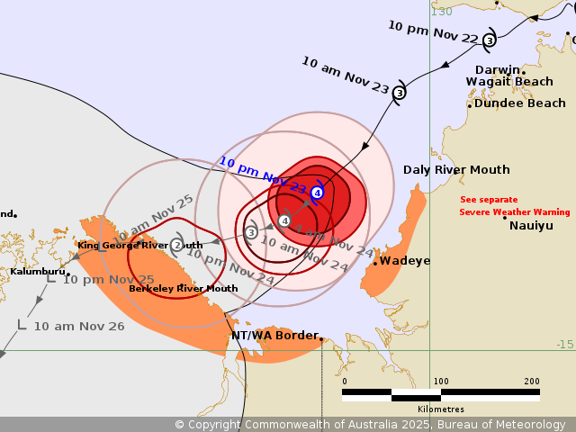
Details of Severe Tropical Cyclone Fina 02U at 9:30 pm ACST [8:00
pm AWST]:
Intensity: Category 4, sustained winds near the centre of 165
kilometres per hour with wind gusts to 230 kilometres per
hour.
Location: within 20 kilometres of 13.5 degrees South 129.0 degrees
East, estimated to be 180 kilometres west southwest of Dundee Beach
and 165 kilometres northeast of Berkeley River Mouth.
Movement: southwest at 10 kilometres per hour.
Fina remains a small, category 4 cyclone. It is slowly tracking
southwest with its destructive core remaining offshore from the
western Top End.
Fina is forecast to remain a severe tropical cyclone overnight
Sunday as it moves southwest through the Joseph Bonaparte Gulf.
Fina is expected to take a more westerly track towards the
northeast Kimberley coast during Monday, weakening rapidly as it
does so. The cyclone is likely to cross the coast between the NT/WA
Border and Troughton Island late Monday or early Tuesday.
Although Fina is forecast to weaken rapidly as it approaches land,
Category 2 impacts remain possible along the northeast Kimberley
coast during Monday. Fina is likely to weaken quickly below cyclone
strength once it has crossed the coast.
Hazards:
GALES with DAMAGING WIND GUSTS to 120 km/h may develop between
south of Daly River Mouth to Wadeye overnight tonight, but only if
Fina takes a more southerly track.
GALES may extend to coastal parts of the northeast Kimberley in WA
from Monday morning, between King George River Mouth and the WA/NT
Border. Gales may extend east of Kalumburu overnight Monday into
Tuesday as the quickly weakening system moves inland.
DESTRUCTIVE WIND GUSTS to 140 km/h may develop over exposed
coastal areas of the northeast Kimberley coast including King
George River Mouth and Berkeley River Mouth during Monday.
Gales have eased over other parts the northwest Top End, including
Darwin and the Tiwi Islands. A Severe Weather Warning for damaging
wind gusts with showers and thunderstorms is current. Please refer
to
https://www.bom.gov.au/weather-and-climate/warnings-and-alerts
HEAVY to LOCALLY INTENSE RAINFALL, which may lead to FLASH
FLOODING, about the coastal areas south of Daly River Mouth to
Wadeye, then extending to the northeast Kimberley coast later on
Monday. Refer to the adjacent Severe Weather Warning for heavy
rainfall over the northwest Top End.
Coastal residents on the Tiwi Islands, and between Cape Hotham and
Warruwi in the Northern Territory are specifically warned that
tides may continue to rise above the normal high tide mark on
Sunday with LARGE WAVES and MINOR FLOODING of low-lying coastal
areas. This extends to coastal residents in Western Australia
between King George River Mouth and the NT/WA Border for tides on
Monday night.
Recommended Action:
NTES advises people between Daly River Mouth and Wadeye should
immediately commence or continue preparations, especially securing
boats and property, using available daylight hours.
For cyclone preparedness and safety advice, visit the Secure NT
website (https://securent.nt.gov.au). For emergency assistance call
the Northern Territory Emergency Service (NTES) on 132 500 (for
assistance with storm damage, rising flood water, fallen trees on
buildings or roof damage).
NTES advises people in Darwin, Palmerston, Cox Peninsula and Tiwi
Islands should go to Secure NT for post-cyclone safety
information.
For residents in Western Australia DFES advises to ensure you know
what to do in a cyclone. For the latest DFES community alerts and
warnings visit www.emergency.wa.gov.au or download the Emergency WA
app.
Current
Tropical Cyclones
23/Nov/2025 01:11 PM

