
Source: Bureau of Meteorology
Flood Watch for Coastal Rivers between Cooktown to Rockhampton and
the Cape York Peninsula
Issued at 12:10 pm AEST on Saturday 10 January 2026
Flood Watch Number: 23
MINOR TO MAJOR FLOODING POSSIBLE ACROSS COASTAL RIVERS BETWEEN
COOKTOWN TO ROCKHAMPTON AND THE CAPE YORK PENINSULA
Tropical low 12U, in the western Coral Sea, is expected to cross
the Townsville coast on Sunday morning, possibly as a tropical
cyclone. Heavy to locally intense rainfall is forecast over
northeast Queensland, primarily around and south of the system.
Heavy rainfall will extend further south on Sunday, becoming more
isolated from Monday.
Further north, isolated heavy rainfall is also possible across
northern Cape York Peninsula during Saturday. Some elevated river
levels are likely across Cape York Peninsula catchments
Many catchments are wet to saturated following recent heavy
rainfall and rapid and dangerous river level rises are likely,
particularly for the Northern Tropical Coast, and adjacent inland
catchments.
Elevated river levels and areas of flooding are already occurring
in some catchments across northern Queensland, with further minor
to major flooding likely to develop with rainfall during the
remainder of Saturday and into Sunday.
A Severe Weather Warning for heavy, locally intense rainfall is
current for parts of the Flood Watch area. A Tropical Cyclone
Advice is current for parts of the Flood Watch area.
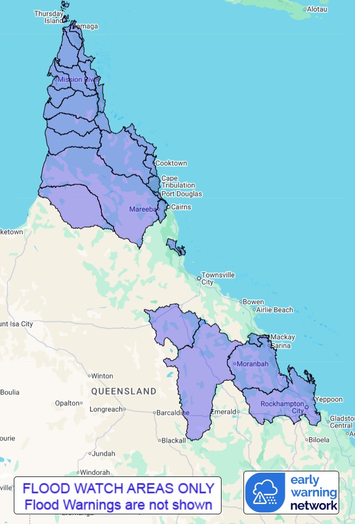
Catchments likely to be affected include:
Jacky Jacky Creek
Olive and Pascoe Rivers
Lockhart River
Stewart River
Normanby River
Jeannie River
Endeavour River
Daintree River(Including Bloomfield River)
Mossman River
Barron River
Murray River
Belyando and Suttor Rivers to Burdekin Falls Dam
Cape River to Burdekin Falls Dam
Pioneer River
Connors, Isaac and Styx Rivers and Plane Creek
Mackenzie and Fitzroy Rivers and Shoalwater and Water Park
Creeks
Staaten River
Mitchell River
Coleman and Edward Rivers
Holroyd and Kendall Rivers
Archer and Coen Rivers
Watson River
Embley and Mission Rivers
Wenlock River
Ducie, Jackson and Skardon Rivers
Jardine River
Flood warnings are current for the following catchment(s) :
Daintree, Mulgrave and Russell, Tully, Herbert, Ross, Bohle, Black,
Haughton, Upper Burdekin, Lower Burdekin, Don, Upper Flinders,
Lower Flinders, Norman, Gilbert, Georgina and Eyre, Diamantina and
Thomson
For the latest flood and weather warnings see
www.bom.gov.au/weather-and-climate/warnings-and-alerts
For the latest rainfall and river level information see
www.bom.gov.au/australia/flood
Safety Advice:
Don't drive, walk, swim or play in floodwater because it is
dangerous.
Stay away from flooded drains, rivers, streams and
waterways.
Obey road closure signs. Plan ahead so you don't drive on flooded
roads.
Check the ABC and local media for updates. The situation can
change quickly, so stay informed.
For local emergency management warnings and advice visit
www.disaster.qld.gov.au/warnings.
For emergency assistance call SES on telephone number 132 500. In
life-threatening emergencies, call 000 (triple zero)
immediately.
Rainfall and River
Conditions Map
10/Jan/2026 02:29 AM


