
Source: Bureau of Meteorology
Issued at 12:40 pm AEST on Tuesday 24 March 2026
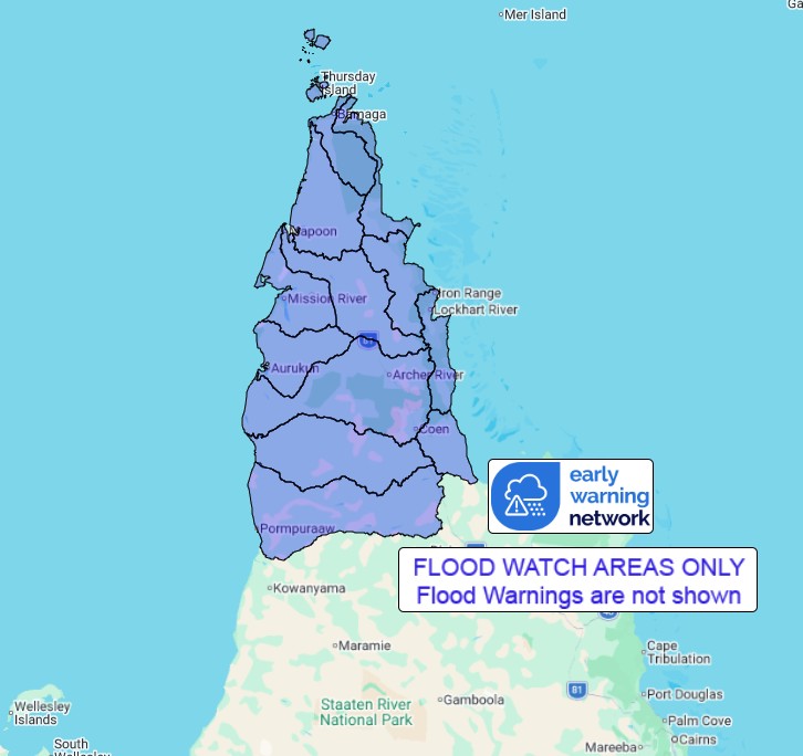
Flood Watch Number: 23
FLOODING EXPECTED TO BE CONTINUING ACROSS PARTS OF THE CAPE YORK
PENINSULA
Isolated moderate rainfall remains possible about parts of the
Cape York Peninsula during the remainder of Tuesday, contracting
north and mostly easing by Wednesday. Significant widespread
rainfall is not expected over the Flood Watch area for next few
days, thus the risk of further flooding developing is low.
Flooding is expected to be occurring at many locations across the
Cape York Peninsula following rainfall from late last week and over
the weekend with the passage of Ex-Tropical Cyclone Narelle.
Catchments across the Flood Watch area remain saturated and will
respond quickly to further rainfall. Disruption to transport routes
is occurring or likely across parts of the Flood Watch area.
Catchments likely to be affected include:
Jacky Jacky Creek
Olive and Pascoe Rivers
Lockhart River
Stewart River
Coleman and Edward Rivers
Holroyd and Kendall Rivers
Archer and Coen Rivers
Watson River
Embley and Mission Rivers
Wenlock River
Ducie, Jackson and Skardon Rivers
Jardine River
Flooding is no longer expected in the following catchment(s):
Normanby, Jeannie and Endeavour
For the latest flood and weather warnings see
www.bom.gov.au/weather-and-climate/warnings-and-alerts
For the latest rainfall and river level information see
www.bom.gov.au/australia/flood
Safety Advice:
Don't drive, walk, swim or play in floodwater because it is
dangerous.
Stay away from flooded drains, rivers, streams and
waterways.
Obey road closure signs. Plan ahead so you don't drive on flooded
roads.
Check the ABC and local media for updates. The situation can
change quickly, so stay informed.
For local emergency management warnings and advice visit
www.disaster.qld.gov.au/warnings.
For emergency assistance call SES on telephone number 132 500. In
life-threatening emergencies, call 000 (triple zero)
immediately.
Rainfall and River
Conditions Map
24/Mar/2026 02:48 AM

