
Source: Bureau of Meteorology
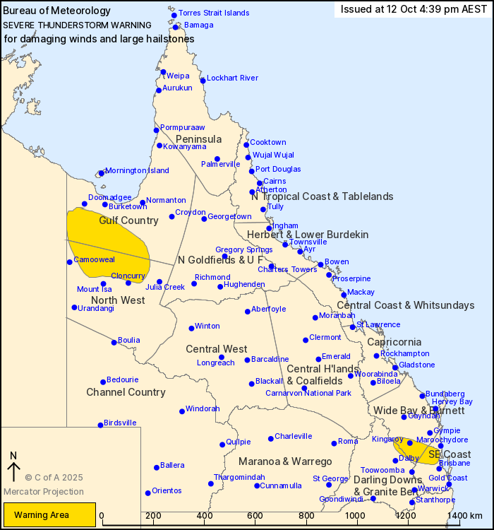
For people in parts of Gulf Country, North West, Wide Bay and
Burnett, Darling Downs and Granite Belt and Southeast Coast
Forecast Districts.
Issued at 4:39 pm Sunday, 12 October 2025.
Severe storms have developed in the far southeast and continue in
the far northwest.
Weather Situation: A surface trough extends from the Gulf Country
through the centre of the state and into the far southeast. A moist
and unstable airmass is in place around the trough and has caused
severe thunderstorms to develop this afternoon.
Severe thunderstorms are likely to produce damaging winds and
large hailstones over the next several hours in parts of the Wide
Bay and Burnett, Darling Downs and Granite Belt and Southeast Coast
districts. Locations which may be affected include Kingaroy,
Nanango, Caboolture, Esk, Kilcoy and Woodford.
Severe thunderstorms are likely to produce damaging winds over the
next several hours in parts of the Gulf Country and North West
districts. Locations which may be affected include Kamilaroi
Station, Augustus Downs Station, Riversleigh Station, Gregory Downs
Station and Lawn Hill.
A 94 km/h gust was recorded at Cloncurry Airport at 12:57pm.
Emergency services advise people to:
* Park your car undercover away from trees.
* Close doors and windows.
* Keep asthma medications close by. Storms and wind can trigger
asthma attacks.
* Charge mobile phones and power banks in case the power goes
out.
* Put your pets somewhere safe and make sure they can be
identified in case they get lost.
* Do not drive now unless you have to because conditions are
dangerous.
* Tell friends, family and neighbours in the area.
* Go inside a strong building now. Stay inside until the storm has
passed.
12/Oct/2025 07:58 AM


