
Source: Bureau of Meteorology
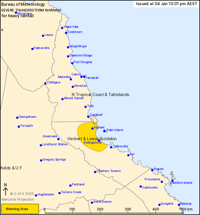
For people in parts of Herbert and Lower Burdekin and North
Tropical Coast and Tablelands Forecast Districts.
Issued at 10:01 pm Sunday, 4 January 2026.
Localised heavy rainfall likely over parts of NE Qld this
evening.
Weather Situation: An airmass featuring deep tropical moisture and
moderate instability remains in place over northeastern Queensland,
with several weak troughs in the area that may provide a focus for
development of thunderstorms and heavy rainfall.
Severe thunderstorms are likely to produce heavy rainfall that may
lead to flash flooding in the warning area over the next several
hours. Locations which may be affected include Palm Island, Ingham,
Rollingstone, Lucinda and Abergowrie.
Severe thunderstorms are no longer occurring in the Northern
Goldfields and Upper Flinders district and the warning for this
district is CANCELLED.
Emergency services advise people to:
* Park your car undercover away from trees.
* Close doors and windows.
* Keep asthma medications close by. Storms and wind can trigger
asthma attacks.
* Charge mobile phones and power banks in case the power goes
out.
* Put your pets somewhere safe and make sure they can be
identified in case they get lost.
* Do not drive now unless you have to because conditions are
dangerous.
* Tell friends, family and neighbours in the area.
* Go inside a strong building now. Stay inside until the storm has
passed.
04/Jan/2026 12:05 PM


