
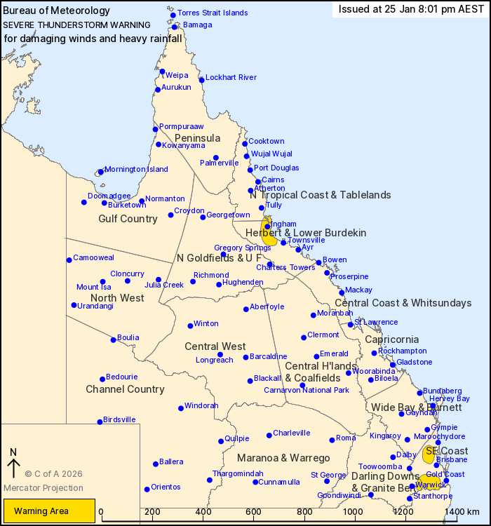
Source: Bureau of Meteorology
For people in parts of North Tropical Coast and Tablelands,
Herbert and Lower Burdekin, Darling Downs and Granite Belt and
Southeast Coast Forecast Districts.
Issued at 8:01 pm Sunday, 25 January 2026.
Isolated severe thunderstorms ongoing about the southeast. Heavy
rainfall developing about the Herbert and Lower Burdekin
coast.
Weather Situation: Severe thunderstorms are ongoing in an unstable
airmass about southeast Queensland this evening. Further north,
heavy rainfall has developed about a coastal trough near the
Herbert and Lower Burdekin coast.
Severe thunderstorms are likely to produce damaging winds over the
next several hours in parts of the Darling Downs and Granite Belt
and Southeast Coast districts. Locations which may be affected
include Caboolture, Boonah, Beaudesert, Kilcoy and Woodford.
Severe thunderstorms are likely to produce heavy rainfall that may
lead to flash flooding over the next several hours in parts of the
North Tropical Coast and Tablelands and Herbert and Lower Burdekin
districts. Locations which may be affected include Ingham, Palm
Island, Lucinda and Rollingstone.
Severe thunderstorms are no longer occurring in the Wide Bay and
Burnett district and the warning for this district is
CANCELLED.
102.0 mm of rainfall was recorded at Gairloch Alert (near Ingham)
in the 1 hour to 7:51 pm.
Emergency services advise people to:
* Park your car undercover away from trees.
* Close doors and windows.
* Keep asthma medications close by. Storms and wind can trigger
asthma attacks.
* Charge mobile phones and power banks in case the power goes
out.
* Put your pets somewhere safe and make sure they can be
identified in case they get lost.
* Do not drive now unless you have to because conditions are
dangerous.
* Tell friends, family and neighbours in the area.
* Go inside a strong building now. Stay inside until the storm has
passed.
25/Jan/2026 10:05 AM

