
Source: Bureau of Meteorology
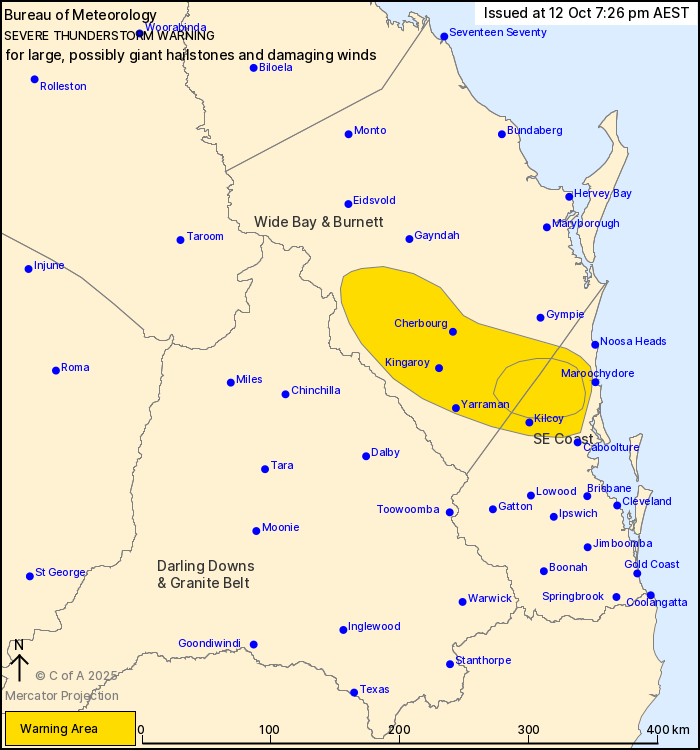
For people in parts of Wide Bay and Burnett and Southeast Coast
Forecast Districts.
Issued at 7:26 pm Sunday, 12 October 2025.
GIANT HAIL IS POSSIBLE IN THUNDERSTORMS NORTH OF KILCOY.
Weather Situation: A moist and unstable airmass is in place around
a surface trough through inland parts of the southeast, which has
caused severe thunderstorms to develop. Thunderstorms are moving to
the east and southeast and are likely to continue into the evening
but will likely weaken before they reach the coast.
VERY DANGEROUS THUNDERSTORMS are likely to produce large, possibly
giant hailstones and damaging winds over the next several hours in
parts of the Wide Bay and Burnett and Southeast Coast districts.
Locations which may be affected include Nambour.
Severe thunderstorms are likely to produce damaging winds and
large hailstones over the next several hours in parts of the Wide
Bay and Burnett and Southeast Coast districts. Locations which may
be affected include Kingaroy, Cherbourg, Kilcoy, Yarraman, Nambour
and Nanango.
Severe thunderstorms are no longer occurring in the Darling Downs
and Granite Belt district and the warning for this district is
CANCELLED.
6 CM HAILSTONES WERE OBSERVED AT BELLTHORPE AROUND 5:00 PM.
4 cm hailstones were observed at Stanmore around 5:15 pm.
Emergency services advise people to:
* If you have children make sure they are with you or an adult you
trust.
* Stay away from windows if there is giant hail.
* Park your car undercover away from trees.
* Close doors and windows.
* Keep asthma medications close by. Storms and wind can trigger
asthma attacks.
* Charge mobile phones and power banks in case the power goes
out.
* Put your pets somewhere safe and make sure they can be
identified in case they get lost.
* Do not drive now unless you have to because conditions are
dangerous.
* Tell friends, family and neighbours in the area.
* Go inside a strong building now. Stay inside until the storm has
passed.
12/Oct/2025 09:31 AM

