
Source: Bureau of Meteorology
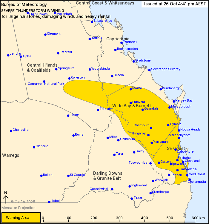
For people in Wide Bay and Burnett, Southeast Coast and parts of
Central Highlands and Coalfields, Capricornia and Darling Downs and
Granite Belt Forecast Districts.
Issued at 4:41 pm Sunday, 26 October 2025.
Scattered severe thunderstorms over southeast Queensland and
moving towards the coast this afternoon and evening.
Weather Situation: A relatively moist and unstable airmass is in
place over most of southeast Queensland. This will combine with
strong winds in the upper atmosphere ahead of an approaching
upper-level trough to provide a favourable environment scattered
severe thunderstorms this afternoon and evening, including a few
supercells.
Severe thunderstorms are likely to produce large hailstones,
damaging winds and heavy rainfall that may lead to flash flooding
in the warning area over the next several hours. Locations which
may be affected include Gold Coast, Brisbane, Maroochydore, Gympie,
Ipswich, Kingaroy, Cleveland, Gatton, Jimboomba, Coolangatta and
Caboolture.
96 km/h wind gust was recorded at Archerfield Airport at 4:34
pm.
94 km/h wind gust was recorded at Amberley RAAF at 4:13 pm.
4cm hail was reported near Ipswich at 4:10 pm.
Emergency services advise people to:
* Park your car undercover away from trees.
* Close doors and windows.
* Keep asthma medications close by. Storms and wind can trigger
asthma attacks.
* Charge mobile phones and power banks in case the power goes
out.
* Put your pets somewhere safe and make sure they can be
identified in case they get lost.
* Do not drive now unless you have to because conditions are
dangerous.
* Tell friends, family and neighbours in the area.
* Go inside a strong building now. Stay inside until the storm has
passed.
26/Oct/2025 06:48 AM


