
Source: Bureau of Meteorology
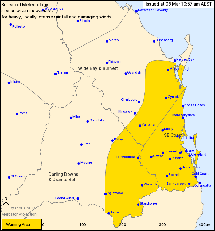
For people in Southeast Coast and parts of Wide Bay and Burnett
and Darling Downs and Granite Belt Forecast Districts.
Issued at 10:57 am Saturday, 8 March 2025.
EX-TROPICAL CYCLONE ALFRED HAS WEAKENED BUT HEAVY TO LOCALLY
INTENSE RAINFALL AND DAMAGING WIND GUSTS ARE STILL EXPECTED OVER
SOUTHEAST QUEENSLAND.
Ex-Tropical Cyclone Alfred lies just off Bribie Island and is slow
moving to the west-northwest, it is expected to make landfall along
the coastline between Maroochydore and Bribie Island over the next
several hours before moving inland and weakening later today. Bands
of heavy rainfall have been occurring over the South East coast,
with damaging wind gusts affecting coastal and island
communities.
HEAVY RAINFALL which may lead to FLASH FLOODING is expected to
continue to develop across the South East coast today, becoming
more widespread over the warning area later today and on Sunday as
the system moves inland, including Brisbane, Ipswich, the Sunshine
Coast and Gympie. Six-hourly rainfall totals between 80 and 130 mm
are likely today and into Sunday morning. 24-hourly totals between
120 and 200 mm are likely.
Locally INTENSE RAINFALL which may lead to DANGEROUS AND
LIFE-THREATENING FLASH FLOODING may develop later today and on
Sunday near and south of the system centre, and in bands of showers
and thunderstorms wrapping around the system over the South East
coast and southern Wide Bay and Burnett which may include Brisbane,
Ipswich and the Sunshine Coast. Six-hourly rainfall totals between
150 and 210 mm and 24-hourly totals between 300 and 400 mm are
possible. All rainfall numbers are dependent on the movement and
position of the system.
DAMAGING WIND GUSTS with peak gusts around 100 km/h are possible
today in bands of showers and thunderstorms wrapping around the
system over the South East coast and southern Wide Bay and Burnett,
and about elevated terrain over the South East coast. DAMAGING WIND
GUSTS with peak gusts to around 90 km/h extending to elevated
terrain of the eastern Darling Downs and Granite Belt during the
evening.
A Tropical Cyclone Forecast Track Map is current for Tropical
Cyclone Alfred.
A Coastal Hazard Warning and Hazardous Surf Warning is
current.
A Flood Watch and Flood Warnings are current for southern and
southeastern Queensland.
For these products, see
http://www.bom.gov.au/australia/warnings/
Locations which may be affected include Warwick, Gold Coast,
Toowoomba, Brisbane, Maroochydore, Gympie, Stanthorpe, Caboolture,
Coolangatta and Ipswich.
119 mm was recorded at Carbrook in the 3 hours to 2:00 am.
Sustained 65 km/h winds were recorded at Redcliffe at 2:00
am.
Sustained 65 km/h winds were recorded at Brisbane Airport at 11:20
pm.
93 km/h wind gust was recorded at Brisbane Airport at 11:16
pm.
Sustained 75 km/h winds were recorded at Gold Coast Seaway between
9:30 pm and 10:00 pm.
107 km/h wind gust was recorded at Gold Coast Seaway at 9:46
pm.
Emergency services advise people to:
* If you have children make sure they are with you or an adult you
trust.
* Park your car undercover away from trees.
* Close doors and windows.
* Keep asthma medications close by. Storms and wind can trigger
asthma attacks.
* Charge mobile phones and power banks in case the power goes
out.
* Put your pets somewhere safe and make sure they can be
identified in case they get lost.
* Do not drive now unless you have to because conditions are
dangerous.
* Tell friends, family and neighbours in the area.
* Go inside a strong building now. Stay inside until the storm has
passed.
08/Mar/2025 01:08 AM

