
Source: Bureau of Meteorology
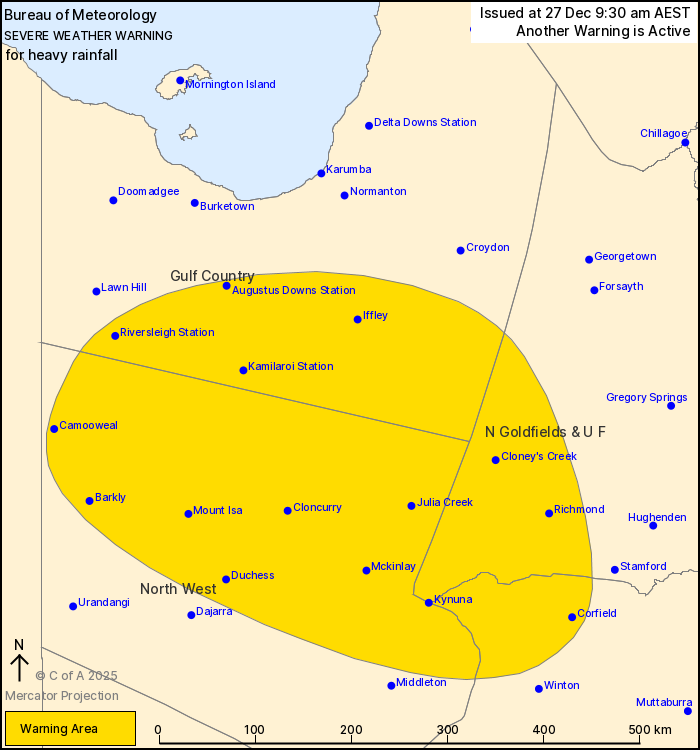
For people in parts of Gulf Country, Northern Goldfields and Upper
Flinders, North West and Central West Forecast Districts.
Issued at 9:30 am Saturday, 27 December 2025.
Heavy rainfall developing about northwest Queensland during
Sunday.
Weather Situation: A monsoon trough extends across the northwest,
containing an embedded low pressure system situated over land west
of the Gulf Country in the Northern Territory. This low is expected
to intensify as it moves into northwest Queensland overnight. These
features are forecast to produce widespread heavy rainfall across
the region.
HEAVY RAINFALL which may lead to FLASH FLOODING is forecast to
develop for parts of Gulf Country, Northern Goldfields and Upper
Flinders, North West and Central West Forecast Districts during
Sunday. Six-hourly rainfall totals between 60 to 110 mm are likely,
with isolated falls up to 150 mm possible.
A separate Severe Thunderstorm Warning will be issued if very
dangerous thunderstorms with intense rainfall are detected.
Areas of heavy rainfall about northwest Queensland are forecast to
persist into early next week, with locations and rainfall totals
subject to the position and strength of the low pressure
system.
Locations which may be affected include Mount Isa, Camooweal,
Cloncurry, Julia Creek, Richmond, Kamilaroi Station, Augustus Downs
Station, Corfield and Riversleigh Station.
Emergency services advise people to:
* Park your car undercover away from trees.
* Close doors and windows.
* Keep asthma medications close by. Storms and wind can trigger
asthma attacks.
* Charge mobile phones and power banks in case the power goes
out.
* Put your pets somewhere safe and make sure they can be
identified in case they get lost.
* Do not drive now unless you have to because conditions are
dangerous.
* Tell friends, family and neighbours in the area.
* Go inside a strong building now. Stay inside until the storm has
passed.
26/Dec/2025 11:39 PM

