
Source: Bureau of Meteorology
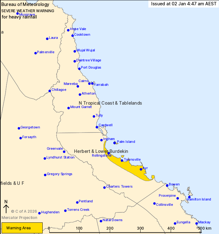
For people in parts of Herbert and Lower Burdekin Forecast
District.
Issued at 4:47 am Friday, 2 January 2026.
Heavy rainfall possible along the coast this morning.
Weather Situation: Converging winds positioned east of Townsville
are combining with a very humid airmass to potentially bring areas
of heavy rain near the coast.
HEAVY RAINFALL which may lead to FLASH FLOODING may re-develop
this morning along the coast between Ingham and Ayr, including
Townsville. Six-hourly rainfall totals between 80 to 150 mm are
possible, with isolated falls in excess of 200 mm possible.
A temporary easing in rainfall may occur this afternoon, with
heavier falls possibly returning to parts of the Herbert and Lower
Burdekin coastline this evening.
Separate Severe Thunderstorm and Flood Watches and/or Warnings are
current at the time of issue. Please refer to
https://www.bom.gov.au/weather-and-climate/warnings-and-alerts for
more information.
Locations which may be affected include Townsville, Palm Island,
Ayr, Rollingstone, Giru and Alva Beach.
152 mm was recorded at Giru in the 3 hours to 2:59pm on
Thursday.
Emergency services advise people to:
* Park your car undercover away from trees.
* Close doors and windows.
* Keep asthma medications close by. Storms and wind can trigger
asthma attacks.
* Charge mobile phones and power banks in case the power goes
out.
* Put your pets somewhere safe and make sure they can be
identified in case they get lost.
* Do not drive now unless you have to because conditions are
dangerous.
* Tell friends, family and neighbours in the area.
* Go inside a strong building now. Stay inside until the storm has
passed.
01/Jan/2026 08:21 PM


