
Source: Bureau of Meteorology
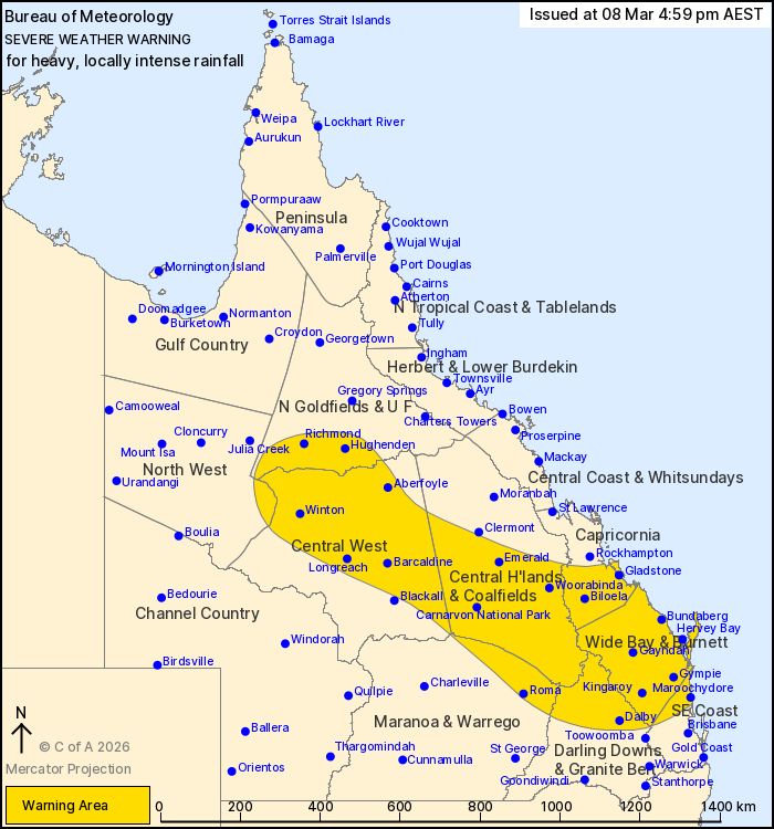
For people in Wide Bay and Burnett and parts of Northern
Goldfields and Upper Flinders, North West, Central Highlands and
Coalfields, Central West, Capricornia, Maranoa and Warrego, Darling
Downs and Granite Belt and Southeast Coast Forecast
Districts.
Issued at 4:59 pm Sunday, 8 March 2026.
LOCALLY INTENSE RAINFALL POSSIBLE IN THE CENTRAL WEST TONIGHT,
WITH HEAVY RAINFALL CONTINUING IN THE SOUTHEAST.
Weather Situation: A low pressure system is currently situated
south of Julia Creek and will gradually move to the southeast
during Sunday and Monday. A trough extends from this low through
central districts and is focusing heavy rainfall through the
central interior. Meanwhile, rich tropical moisture feeding into a
trough in southeastern parts of the state will see rainfall
increasing during Sunday evening and continuing into Monday.
FOR THE CENTRAL INTERIOR: HEAVY RAINFALL which may lead to FLASH
FLOODING is possible today, becoming more likely later tonight.
Six-hourly rainfall totals between 60 and 90 mm are likely.
24-hourly rainfall totals between 100 and 130 mm are likely, with
isolated totals around 180 mm possible. Locally INTENSE RAINFALL
which may lead to DANGEROUS AND LIFE-THREATENING FLASH FLOODING is
also possible in the Central West tonight with six-hourly totals up
to 150 mm.
FOR THE SOUTH EAST: HEAVY RAINFALL which may lead to FLASH
FLOODING is likely over southeastern districts today and during
Monday. Six-hourly rainfall totals between 70 and 120 mm are
likely, with isolated totals around 180 mm possible. 24-hourly
rainfall totals between 80 and 140 mm are likely, with isolated
totals around 250 mm possible.
Various Flood Watches and Flood Warnings are current throughout
Queensland. Separate Severe Thunderstorm Warnings may be current.
Please see
https://www.bom.gov.au/weather-and-climate/warnings-and-alerts for
more information.
Locations which may be affected include Dalby, Maroochydore, Roma,
Gympie, Bundaberg, Gladstone, Emerald, Longreach, Winton, Kingaroy,
Hervey Bay and Biloela.
79 mm was recorded at Caroline Crossing in the 3 hours to 2:50
pm.
79 mm was recorded at Cooranga in the 6 hours to 2:15 pm.
92.8 mm was recorded at Pine Hill Crossing in the 6 hours to 12:44
pm.
99 mm was recorded at Wallumbilla in the 6 hours to 12:12
pm.
73 mm was recorded at Ularunda in the 3 hours to 11:49 am.
56 mm was recorded at Joylands in the 2 hours to 11:11 am.
71 mm was recorded at Wallumbilla in the 3 hours to 9:22 am.
85 mm was recorded at Upper Warrego in the 6 hours to 6:26
am.
Emergency services advise people to:
* If you have children make sure they are with you or an adult you
trust.
* Park your car undercover away from trees.
* Close doors and windows.
* Keep asthma medications close by. Storms and wind can trigger
asthma attacks.
* Charge mobile phones and power banks in case the power goes
out.
* Put your pets somewhere safe and make sure they can be
identified in case they get lost.
* Do not drive now unless you have to because conditions are
dangerous.
* Tell friends, family and neighbours in the area.
* Go inside a strong building now. Stay inside until the storm has
passed.
08/Mar/2026 07:39 AM

