
Source: Bureau of Meteorology
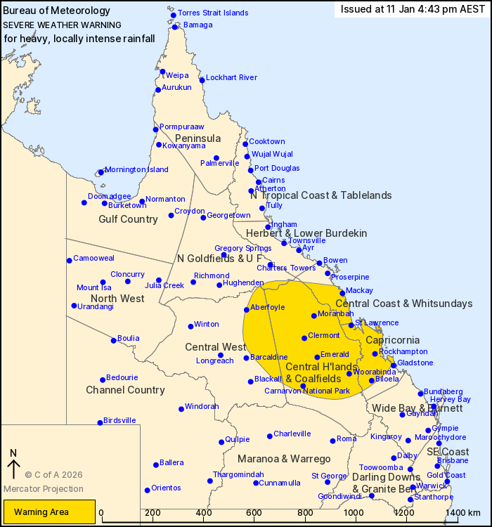
For people in Central Highlands and Coalfields, Capricornia and
parts of Northern Goldfields and Upper Flinders, Central Coast and
Whitsundays and Central West Forecast Districts.
Issued at 4:43 pm Sunday, 11 January 2026.
EX-TROPICAL CYCLONE KOJI HAS MOVED INLAND, WITH HEAVY TO LOCALLY
INTENSE RAINFALL CONTINUING.
Weather Situation: Ex-Tropical Cyclone Koji has moved inland west
of Proserpine, with moist onshore flow and convergence to its
south. It will begin to take a west-northwesterly track over the
northern Central Highlands and Coalfields district tonight.
HEAVY RAINFALL which may lead to FLASH FLOODING is likely along
coastal and adjacent inland parts between Ayr and St Lawrence
today, possibly extending south to Rockhampton into Monday.
Six-hourly rainfall totals between 80 to 150 mm are likely.
24-hourly totals between 150 to 250 mm are likely, with isolated
falls in excess of 340 mm possible. Further inland, HEAVY RAINFALL
which may lead to FLASH FLOODING is forecast to develop from this
evening and continue into Monday, with six-hourly rainfall totals
between 70 and 120 mm likely.
Locally INTENSE RAINFALL which may lead to DANGEROUS AND
LIFE-THREATENING FLASH FLOODING remains possible about coastal and
elevated inland areas between Bowen and St Lawrence today, with
isolated six-hourly falls in excess of 250 mm possible. Locally
INTENSE RAINFALL may develop over parts of the Central Highlands
and Coalfields district later this evening and into Monday, with
six-hourly falls in excess of 150 mm possible.
A Severe Thunderstorm Warning will be issued if intense rainfall
is detected.
Underlying wet soils will make trees easier to fall about the
northeast tropical coast. Landslips could also occur about steep
and hilly terrain.
Flood Watch and Warning products are also current for large parts
of Queensland. For all current warnings and watches please refer to
https://www.bom.gov.au/weather-and-climate/warnings-and-alerts
Locations which may be affected include Emerald, Rockhampton,
Clermont, Mackay, Biloela, Moranbah, St Lawrence, Carnarvon
National Park, Woorabinda, Aberfoyle, Blackwater and Yeppoon.
Severe weather is no longer occurring in the Herbert and Lower
Burdekin district and the warning for this district is
CANCELLED.
Significant observations to 4:30 pm AEST:
241 MM AT RIDGELANDS IN THE 6 HOURS TO 1:02 PM.
264 MM AT UPPER FINCH HATTON CREEK THE 6 HOURS TO 11:34 AM.
291 MM AT MT WILLIAM IN THE 6 HOURS TO 11:00 AM.
255 MM AT CLARKE RANGE IN THE 6 HOURS TO 10:57 AM.
184 mm at East Funnel Creek Rd in the 6 hours to 3 pm.
103 mm at Mt Ewan in the 6 hours to 3 pm.
123 mm at Peak Downs Highway in the 6 hours to 2:41 pm.
143 mm at Mt William in the 3 hours to 12:00 pm.
223 mm at Sennini s Road in the 6 hours to 11:41 am.
217 mm at Finch Hatton Showgrounds in the 6 hours to 11:40
am.
Emergency services advise people to:
* If you have children make sure they are with you or an adult you
trust.
* Park your car undercover away from trees.
* Close doors and windows.
* Keep asthma medications close by. Storms and wind can trigger
asthma attacks.
* Charge mobile phones and power banks in case the power goes
out.
* Put your pets somewhere safe and make sure they can be
identified in case they get lost.
* Do not drive now unless you have to because conditions are
dangerous.
* Tell friends, family and neighbours in the area.
* Go inside a strong building now. Stay inside until the storm has
passed.
11/Jan/2026 06:51 AM


