
Source: Bureau of Meteorology
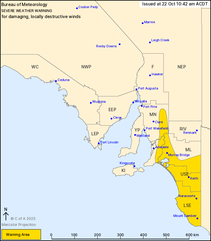
For people in Upper South East, Lower South East and parts of
Mount Lofty Ranges, Mid North and Murraylands districts.
Issued at 10:42 am Wednesday, 22 October 2025.
DAMAGING WINDS OVER THE SOUTHEAST UNTIL MID AFTERNOON, WITH
DESTRUCTIVE WIND GUSTS POSSIBLE ABOUT THE SOUTHEAST COAST UNTIL
EARLY AFTERNOON.
Weather Situation: A vigorous northwest to southwesterly flow is
impacting southeastern South Australia to the north of a low
pressure system, that is just south of Mount Gambier at 10am. Winds
are expected to ease during Wednesday afternoon as the low moves
rapidly away to the east.
Strong northwest to southwesterly winds averaging 50 to 60 km/h
with DAMAGING GUSTS to 100 km/h about the Mount Lofty Ranges and
over the southeast, are expected to continue until mid Wednesday
afternoon.
DAMAGING WINDS averaging 60 to 80 km/h with gusts to 100 to 120
km/h are likely about the coast southeast of Robe until early
afternoon, with the risk of DESTRUCTIVE WIND GUSTS to 130
km/h.
Conditions are expected to ease gradually from the west during the
afternoon on Wednesday.
Locations which may be affected include Robe, Mount Gambier,
Murray Bridge, Naracoorte, Keith, Lameroo and Meningie.
Severe weather is no longer occurring in the Kangaroo Island
district and the warning for this district is CANCELLED.
91 km/h wind gust recorded at Mount Gambier Airport at 10:35
am.
93 km/h wind gust recorded at Robe Airfield at 9:49 am.
93 km/h wind gust recorded at The Limestone at 9:41 am.
The State Emergency Service advises that people should:
* Keep clear of fallen power lines;
* Move vehicles under cover or away from trees;
* Secure or put away loose items around your property.
* Stay indoors, away from windows, while conditions are
severe.
22/Oct/2025 12:16 AM


