
Source: Bureau of Meteorology
For people in parts of North West Pastoral and North East Pastoral
districts.
Issued at 10:49 am Monday, 16 March 2026.
HEAVY RAINFALL ACROSS THE NORTH TODAY, WITH LOCALLY INTENSE
RAINFALL POSSIBLE. INTENSE RAINFALL BECOMES MORE LIKELY NORTH OF
MARREE FROM TONIGHT.
Weather Situation: A tropical low situated in the southwestern NT
is feeding rich tropical moisture along a surface trough to its
southeast. Meanwhile an upper trough is moving across the Nullarbor
coast. The combination of these two systems will bring the risk of
heavy rainfall to northern parts of the state today through to
Wednesday. Heavy rainfall is expected to slowly move eastwards
during the day.
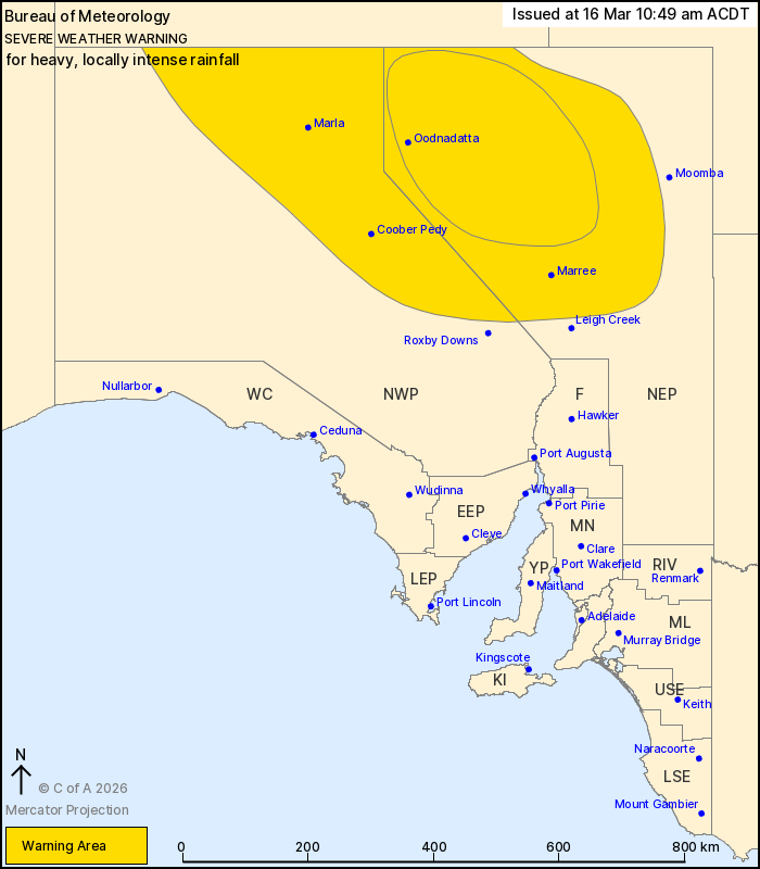
HEAVY RAINFALL which may lead to FLASH FLOODING is forecast for
parts of the North West Pastoral today, extending into the North
East Pastoral during the afternoon. Six-hourly rainfall totals
between 50 and 80 mm are likely. 24-hourly rainfall totals between
80 and 120 mm are likely, with isolated falls around 160 mm
possible.
INTENSE RAINFALL which may lead to DANGEROUS AND LIFE-THREATENING
FLASH FLOODING is locally possible within the warning area, more
likely in northwestern parts of the North East Pastoral district
from late this evening. Six-hourly rainfall totals between 80 and
100 mm are likely, with falls up to 120 mm possible. INTENSE
RAINFALL may begin to ease later on Tuesday morning.
Flood Watches and Warnings are current for the area. Please refer
to https://www.bom.gov.au/weather-and-climate/warnings-and-alerts/
for more information.
Locations which may be affected include Marla, Coober Pedy,
Oodnadatta, Marree, Ernabella and Amata.
The State Emergency Service advises that people should:
* Don't drive, ride or walk through flood water;
* Keep clear of creeks and storm drains;
* Stay indoors, away from windows, while conditions are
severe.
16/Mar/2026 12:23 AM

