
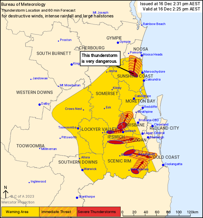
Source: Bureau of Meteorology
For people in parts of Ipswich, Logan, Somerset, Scenic Rim, Gold
Coast, Sunshine Coast, Noosa, Brisbane City, Moreton Bay and
Lockyer Valley Council Areas.
Issued at 2:31 pm Saturday, 16 December 2023.
INTENSE RAINFALL CONTINUES IN THE STORM INLAND OF
MAROOCHYDORE.
The Bureau of Meteorology warns that, at 2:25 pm, a VERY DANGEROUS
THUNDERSTORM likely to produce damaging, locally destructive winds,
intense rainfall that may lead to dangerous and life-threatening
flash flooding and large hailstones was detected near Montville and
Palmwoods. This thunderstorm is moving towards the north. It is
forecast to affect Nambour, Mapleton and Yandina by 2:55 pm and the
area south of Noosa Heads, the area southwest of Noosa Heads and
Cooroy by 3:25 pm.
Other severe thunderstorms likely to produce damaging winds, large
hailstones and heavy rainfall that may lead to flash flooding were
detected near the area between Boonah and Beaudesert, Lake
Manchester and Peak Crossing. These thunderstorms are moving
towards the east to northeast. They are forecast to affect
Beaudesert, Mount Nebo and Highvale by 2:55 pm and Ipswich,
Greenbank and Samford by 3:25 pm.
Emergency services advise people to:
* If you have children make sure they are with you or an adult you
trust.
* Pack away, secure or tie down outdoor furniture, toys and
trampolines if it s safe to do so.
* Park your car undercover away from trees.
* Close doors and windows.
* Keep asthma medications close by. Storms and wind can trigger
asthma attacks.
* Charge mobile phones and power banks in case the power goes
out.
* Put your pets somewhere safe and make sure they can be
identified in case they get lost.
* Do not drive now unless you have to because conditions are
dangerous.
* Tell friends, family and neighbours in the area.
* Go inside a strong building now. Stay inside until the storm has
passed.
16/Dec/2023 04:42 AM


