
Source: Bureau of Meteorology
for HEAVY, LOCALLY INTENSE RAINFALL
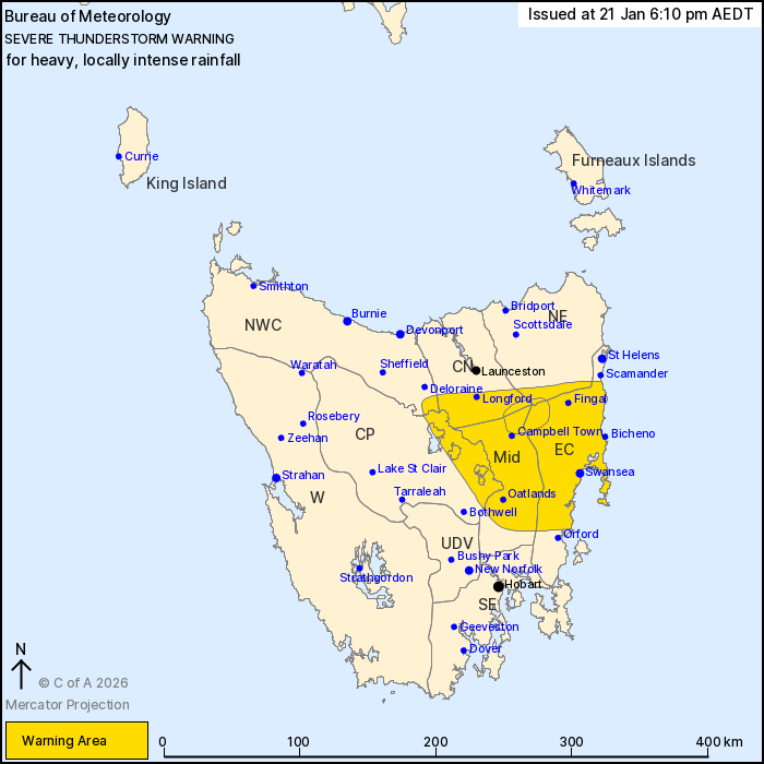
For people in East Coast, Midlands and parts of North East,
Central North, Central Plateau and North West Coast Forecast
Districts.
Issued at 6:10 pm Wednesday, 21 January 2026.
VERY DANGEROUS THUNDERSTORMS with heavy, LOCALLY INTENSE RAINFALL
for parts of northeast Tasmania this afternoon.
Weather Situation: The passage of a cold front combines with an
upper-level trough and high atmospheric moisture to generate severe
thunderstorms with heavy to locally intense rainfall over parts of
northeast Tasmania this afternoon.
VERY DANGEROUS THUNDERSTORMS are likely to produce heavy, locally
intense rainfall that may lead to dangerous and life-threatening
flash flooding over the next several hours in parts of the East
Coast, Midlands, North East and Central North districts.
Severe thunderstorms are likely to produce heavy rainfall that may
lead to flash flooding over the next several hours in the East
Coast, Midlands and parts of the North East, Central North, Central
Plateau and North West Coast districts. Locations which may be
affected include Swansea, Oatlands, Bicheno, Campbell Town, Fingal
and Longford.
37.2 mm of rainfall was recorded at Llewellyn in the 1 hour and 45
minutes to 5:45 pm.
The State Emergency Service advises that people should:
* Avoid driving, walking or riding through flood waters.
* Seek shelter, preferably indoors and never under trees.
* Avoid using the telephone during a thunderstorm.
* Beware of fallen trees and powerlines.
* For emergency assistance contact the SES on 132500.
21/Jan/2026 07:19 AM

