
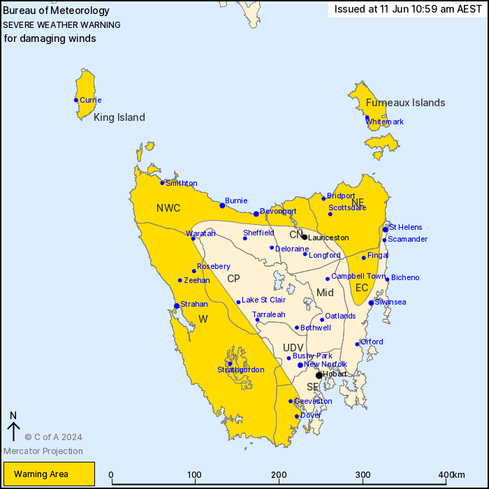
Source: Bureau of Meteorology
For people in King Island, Furneaux Islands, Western, North East,
North West Coast and parts of Upper Derwent Valley, South East,
East Coast, Central North and Central Plateau Forecast
Districts.
Issued at 10:59 am Tuesday, 11 June 2024.
Damaging wind gusts remain possible over western, northern and
northeastern districts until this evening.
Weather Situation: The cold front which brought sustained gales
and damaging wind gusts to parts of northern and western Tasmania
overnight is currently situated over the northeast, with a general
progression towards the east today. Damaging wind gusts remain
possible in showers and thunderstorms in the wake of this front,
with an easing trend later into the afternoon and evening.
West to northwesterly DAMAGING WIND GUSTS of around 100 km/h
remain possible over western, northern and some eastern districts,
including the Furneaux Islands and King Island.
Damaging wind gusts are forecast to ease below warning thresholds
from the west during afternoon and throughout the State by this
evening.
Locations which may be affected include Devonport, Burnie, St
Helens, Strahan, Geeveston and Dover.
Severe weather is no longer occurring in the Midlands district and
the warning for this district is CANCELLED.
67 km/h sustained winds were recorded at Burnie Port around 9:00
am.
65 km/h sustained winds were recorded at Devonport around 7:38
am.
A 128 km/h wind gust was recorded at Scotts Peak Dam at 7:30
am.
The State Emergency Service advises that people should:
* Supervise children closely.
* Check that family and neighbours are aware of warnings.
* Manage pets and livestock.
* Secure outdoor items including furniture and play
equipment.
* Be prepared in case of power outages and report any outages to
TasNetworks on 132 004.
* Beware of damaged trees and power lines and take care when
driving.
* Listen to the ABC radio or check www.ses.tas.gov.au for further
advice.
* For emergency assistance contact the SES on 132500.
11/Jun/2024 01:06 AM

