
Source: Bureau of Meteorology
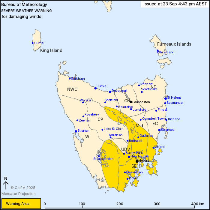
For people in South East, Midlands and parts of Western, Upper
Derwent Valley, East Coast, North West Coast, Central Plateau and
Central North Forecast Districts.
Issued at 4:43 pm Tuesday, 23 September 2025.
Damaging winds with a cold front crossing tonight.
Weather Situation: A cold front crossing over southern Tasmania
tonight is expected to bring strong west to southwesterly winds and
gusty showers over the state, persisting throughout the day on
Wednesday.
DAMAGING WINDS averaging 60 to 70 km/h with peak gusts around 110
km/h are likely about the Western Tiers and southern Tasmania from
late tonight. DAMAGING WINDS averaging 55 to 65 km/h with peak
gusts of around 100 km/h also extend through parts of the Midlands,
East Coast and eastern South East districts, including over Hobart,
during Wednesday morning. For elevated areas and exposed southern
coastal localities, DAMAGING WINDS may average 65 to 75 km/h with
peak gusts around 120 km/h possible.
Winds are expected to ease below warning thresholds by around
mid-afternoon Wednesday.
Locations which may be affected include New Norfolk, Hobart,
Oatlands, Orford, Geeveston and Dover.
The State Emergency Service advises that people should:
* Supervise children closely.
* Check that family and neighbours are aware of warnings.
* Manage pets and livestock.
* Secure outdoor items including furniture and play
equipment.
* Be prepared in case of power outages and report any outages to
TasNetworks on 132 004.
* Beware of damaged trees and power lines and take care when
driving.
* Listen to the ABC radio or check www.ses.tas.gov.au for further
advice.
* For emergency assistance contact the SES on 132500.
23/Sep/2025 06:53 AM

