
Source: Bureau of Meteorology
For people in North Central and parts of Northern Country, North
East, West and South Gippsland and Central Forecast
Districts.
Issued at 4:20 pm Wednesday, 11 February 2026.
Gusty winds with showers and possible thunderstorms this afternoon
and evening.
Weather Situation: A blustery front and trough move through the
state this afternoon and evening, bringing the risk of gusty winds
with showers or thunderstorms.
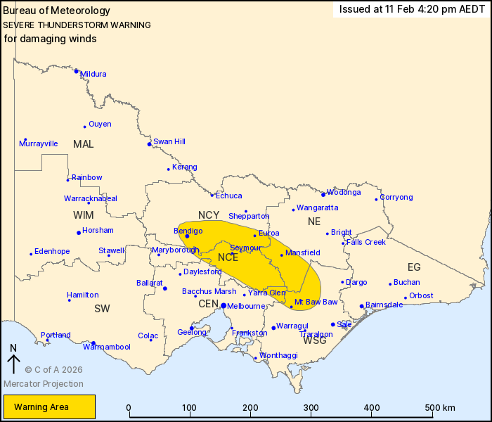
Severe showers or thunderstorms are likely to produce damaging
winds in the warning area over the next several hours. Locations
which may be affected include Bendigo, Seymour, Euroa, Mansfield,
Mt Baw Baw and Mt Buller.
A 98 km/h gust was observed at Puckapunyal Lyon Hill (Defence) at
4:05 pm.
The State Emergency Service advises that people should:
* If driving conditions are dangerous, safely pull over away from
trees, drains, low-lying areas and floodwater. Avoid travel if
possible.
* Stay safe by avoiding dangerous hazards, such as floodwater,
mud, debris, damaged roads and fallen trees.
* Be aware - heat, fire or recent storms may make trees unstable
and more likely to fall when it's windy or wet.
* Check that loose items, such as outdoor settings, umbrellas and
trampolines are safely secured. Move vehicles under cover or away
from trees.
* Stay indoors and away from windows.
* If outdoors, move to a safe place indoors. Stay away from trees,
drains, gutters, creeks and waterways.
* Stay away from fallen powerlines - always assume they are
live.
* Be aware that in fire affected areas, rainfall run-off into
waterways may contain debris such as ash, soil, trees and rocks.
Heavy rainfall may also increase the potential for landslides and
debris across roads.
* Stay informed: Monitor weather warnings, forecasts and river
levels at the Bureau of Meteorology website, and warnings through
VicEmergency website/app/hotline.
11/Feb/2026 05:39 AM


