
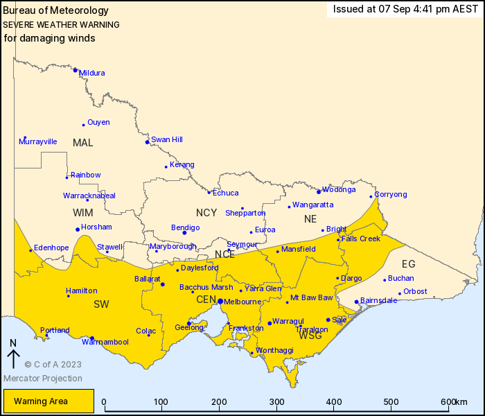
Source: Bureau of Meteorology
For people in Central, South West, West and South Gippsland and
parts of East Gippsland, North Central, North East and Wimmera
Forecast Districts.
Issued at 4:41 pm Thursday, 7 September 2023.
Damaging wind gusts are possible during Thursday and Friday.
Weather Situation: A cold front is crossing Victoria today as a
low pressure system develops over waters to the southwest of the
state, bringing strengthening northerly winds ahead of the front. A
strong and gusty southwesterly change will then move into the
southwest of the state early on Friday morning around the low
pressure system, which will then move through Bass Strait and
affect southern parts of Victoria during the remainder of
Friday.
Strong northerly winds averaging 50 to 60 km/h with DAMAGING WIND
GUSTS of around 90 to 100 km/h are possible over the Grampians, the
Otways, central ranges, eastern ranges and areas of higher terrain
in Gippsland during Thursday. This also includes the northern
suburbs of Melbourne.
Winds in the central and western parts of the state, including the
northern suburbs of Melbourne, will initially ease below warning
thresholds by early Thursday evening, though are likely to remain
fresh and gusty into Friday morning.
Locally DAMAGING WINDS averaging 60 to 70 km/h with peak gusts of
up to 110km/h are likely to re-develop over the far southwest coast
from around midnight and extend along coastal areas during Friday,
with a possibly risk over the Geelong area and the Mornington
Peninsula during the morning and early afternoon.
West to southwesterly winds averaging 50 to 60 km/h with DAMAGING
WIND GUSTS of around 90 to 100 km/h are possible over remaining
southern parts of the state inland from the coast, including the
greater Melbourne area, and West and South Gippsland after sunrise
on Friday and continuing into the afternoon.
Conditions are expected to ease over western parts of the state
during late Friday afternoon, over central parts including
Melbourne during early Friday evening and contract to only eastern
parts of the State by late Friday evening, before easing early
Saturday morning.
Locations which may be affected include Warrnambool, Ballarat,
Geelong, Melbourne, Traralgon and Moe.
122 km/h wind gust was recorded at Mount William at 3:45 PM.
98 km/h wind gust was recorded at Mt Gellibrand at 4:09 PM.
98 km/h wind gust was recorded at Falls Creek at 1:50 PM.
96 km/h wind gust was recorded at Ben Nevis at 12:05 PM.
94 km/h wind gust was recorded at Mount Hotham at 10:56 AM.
The State Emergency Service advises that people should:
* If driving conditions are dangerous, safely pull over away from
trees, drains, low-lying areas and floodwater. Avoid travel if
possible.
* Stay safe by avoiding dangerous hazards, such as floodwater,
mud, debris, damaged roads and fallen trees.
* Be aware - heat, fire or recent storms may make trees unstable
and more likely to fall when it's windy or wet.
* Check that loose items, such as outdoor settings, umbrellas and
trampolines are safely secured. Move vehicles under cover or away
from trees.
* Stay indoors and away from windows.
* If outdoors, move to a safe place indoors. Stay away from trees,
drains, gutters, creeks and waterways.
* Stay away from fallen powerlines - always assume they are
live.
* Be aware that in fire affected areas, rainfall run-off into
waterways may contain debris such as ash, soil, trees and rocks.
Heavy rainfall may also increase the potential for landslides and
debris across roads.
* Stay informed: Monitor weather warnings, forecasts and river
levels at the Bureau of Meteorology website, and warnings through
VicEmergency website/app/hotline.
07/Sep/2023 06:49 AM


