
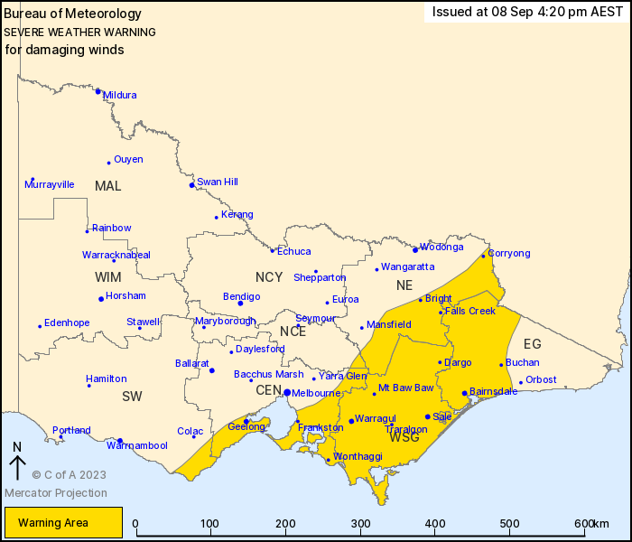
Source: Bureau of Meteorology
For people in West and South Gippsland and parts of Central, East
Gippsland, North East, South West and North Central Forecast
Districts.
Issued at 4:20 pm Friday, 8 September 2023.
Damaging wind gusts possible, easing from the west during the
evening.
Weather Situation: A low pressure system continues to move
eastwards through Bass Strait this afternoon. Fresh to strong
northwesterly winds are in place over eastern parts of the state,
shifting to strong and gusty west to southwesterly winds into the
evening.
Northwesterly winds averaging 50 to 60 km/h with DAMAGING WIND
GUSTS of around 90 km/h are possible over the eastern ranges,
including areas of higher terrain in Gippsland.
West to southwesterly DAMAGING WINDS averaging 60 to 70 km/h with
peak gusts around 90km/h are occurring over the central coasts and
Gippsland coast.
West to southwesterly winds averaging 50 to 60 km/h with DAMAGING
WIND GUSTS of around 90 km/h are possible over remaining southern
parts of the state inland from the coast.
Conditions are expected to broadly ease during Friday
evening.
A separate Severe Weather Warning is current for damaging surf,
refer to www.bom.gov.au/warnings
Locations which may be affected include Geelong, Morwell,
Traralgon, Sale, Moe and Bairnsdale.
Severe weather is no longer occurring in the Wimmera district and
the warning for this district is CANCELLED.
111 km/h wind gust was recorded at Mt Nowa Nowa at 08:34 AM.
111 km/h wind gust was recorded at Mt Gellibrand at 08:29
AM.
109 km/h wind gust was recorded at Port Fairy at 07:05 AM.
106 km/h wind gust was recorded at Warnambool at 07:40 AM.
74km/h sustained winds and 102 km/h wind gust was recorded at
Avalon Airport about 10:35 AM.
93 km/h wind gust was recorded at Portland at 4:36 AM.
The State Emergency Service advises that people should:
* If driving conditions are dangerous, safely pull over away from
trees, drains, low-lying areas and floodwater. Avoid travel if
possible.
* Stay safe by avoiding dangerous hazards, such as floodwater,
mud, debris, damaged roads and fallen trees.
* Be aware - heat, fire or recent storms may make trees unstable
and more likely to fall when it's windy or wet.
* Check that loose items, such as outdoor settings, umbrellas and
trampolines are safely secured. Move vehicles under cover or away
from trees.
* Stay indoors and away from windows.
* If outdoors, move to a safe place indoors. Stay away from trees,
drains, gutters, creeks and waterways.
* Stay away from fallen powerlines - always assume they are
live.
* Be aware that in fire affected areas, rainfall run-off into
waterways may contain debris such as ash, soil, trees and rocks.
Heavy rainfall may also increase the potential for landslides and
debris across roads.
* Stay informed: Monitor weather warnings, forecasts and river
levels at the Bureau of Meteorology website, and warnings through
VicEmergency website/app/hotline.
08/Sep/2023 06:27 AM


