
Source: Bureau of Meteorology
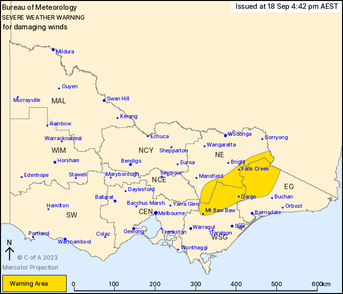
For people in parts of East Gippsland, North East, West and South
Gippsland, Central and North Central Forecast Districts.
Issued at 4:42 pm Monday, 18 September 2023.
Damaging winds about the eastern ranges from Tuesday
afternoon.
Weather Situation: Northwesterly winds will strengthen during
Tuesday ahead of a cold front which is expected to cross eastern
Victoria later on Wednesday morning.
DAMAGING WINDS, averaging 60 to 70 km/h with peak gusts of around
100 km/h are likely about elevated parts of the warning area from
Tuesday afternoon.
Winds are expected to ease below warning thresholds by late
Wednesday morning.
Locations which may be affected include Dargo, Mt Baw Baw, Falls
Creek, Mt Hotham, Mt Buller and Omeo.
The State Emergency Service advises that people should:
* If driving conditions are dangerous, safely pull over away from
trees, drains, low-lying areas and floodwater. Avoid travel if
possible.
* Stay safe by avoiding dangerous hazards, such as floodwater,
mud, debris, damaged roads and fallen trees.
* Be aware - heat, fire or recent storms may make trees unstable
and more likely to fall when it's windy or wet.
* Check that loose items, such as outdoor settings, umbrellas and
trampolines are safely secured. Move vehicles under cover or away
from trees.
* Stay indoors and away from windows.
* If outdoors, move to a safe place indoors. Stay away from trees,
drains, gutters, creeks and waterways.
* Stay away from fallen powerlines - always assume they are
live.
* Be aware that in fire affected areas, rainfall run-off into
waterways may contain debris such as ash, soil, trees and rocks.
Heavy rainfall may also increase the potential for landslides and
debris across roads.
* Stay informed: Monitor weather warnings, forecasts and river
levels at the Bureau of Meteorology website, and warnings through
VicEmergency website/app/hotline.
18/Sep/2023 06:49 AM


