
Source: Bureau of Meteorology
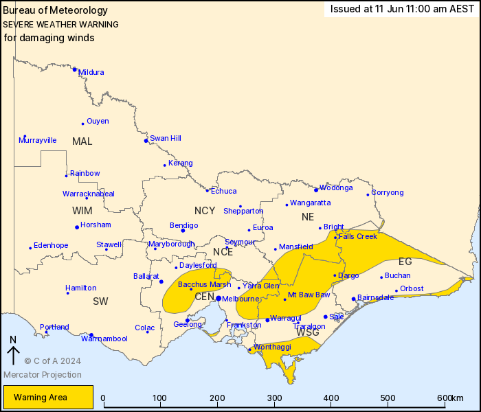
For people in parts of Central, East Gippsland, North Central,
North East and West and South Gippsland Forecast Districts.
Issued at 11:00 am Tuesday, 11 June 2024.
Damaging sustained winds and gusts expected over parts of Victoria
today and into tomorrow morning.
Weather Situation: A vigorous cold front will move eastwards
across Victoria today, currently in the centre of the state and
clearing to the east by late in the day. A second cold front will
brush the coastal parts of Gippsland later tonight and early
tomorrow morning.
For the MACEDON RANGES, OUTER NORTHERN AND WESTERN SUBURBS OF
MELBOURNE and MORNINGTON PENINSULA: Strong winds averaging 60 to 70
km/h with DAMAGING WIND GUSTS of around 90 km/h are expected. Winds
will ease by the early afternoon today.
For parts of NORTHEAST RANGES: Strong winds averaging 50 to 60
km/h with DAMAGING WIND GUSTS up to 120 km/h are expected for
elevations above 1200 metres and on the southern slopes of the
ranges. These conditions are expected to ease by this
evening.
For the GIPPSLAND COAST: Strong west to southwesterly DAMAGING
WINDS averaging 60 to 70 km/h with peak gusts of around 90 km/h
with showers or thunderstorms, will develop in the late evening
today and continue through early tomorrow morning. These conditions
are likely to contract to only coastal parts of East Gippsland by
late Wednesday morning, before easing later in the afternoon.
Locations which may be affected include Wonthaggi, Bacchus Marsh,
Falls Creek, Mt Hotham, Mt Buller and Omeo.
Severe weather is no longer occurring in the South West district
and the warning for this district is CANCELLED.
The State Emergency Service advises that people should:
* If driving conditions are dangerous, safely pull over away from
trees, drains, low-lying areas and floodwater. Avoid travel if
possible.
* Stay safe by avoiding dangerous hazards, such as floodwater,
mud, debris, damaged roads and fallen trees.
* Be aware - heat, fire or recent storms may make trees unstable
and more likely to fall when it's windy or wet.
* Check that loose items, such as outdoor settings, umbrellas and
trampolines are safely secured. Move vehicles under cover or away
from trees.
* Stay indoors and away from windows.
* If outdoors, move to a safe place indoors. Stay away from trees,
drains, gutters, creeks and waterways.
* Stay away from fallen powerlines - always assume they are
live.
* Be aware that in fire affected areas, rainfall run-off into
waterways may contain debris such as ash, soil, trees and rocks.
Heavy rainfall may also increase the potential for landslides and
debris across roads.
* Stay informed: Monitor weather warnings, forecasts and river
levels at the Bureau of Meteorology website, and warnings through
VicEmergency website/app/hotline.
11/Jun/2024 01:16 AM

