
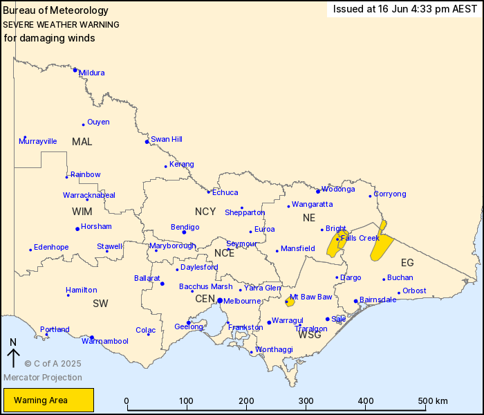
Source: Bureau of Meteorology
For people in parts of East Gippsland, North East and West and
South Gippsland Forecast Districts.
Issued at 4:33 pm Monday, 16 June 2025.
Damaging winds developing about Alpine areas on Tuesday with
blizzard conditions.
Weather Situation: Westerly winds are expected to strengthen
across elevated parts of northeast Victoria from early Tuesday
morning in response to a low pressure system to the south of
Tasmania.
DAMAGING WINDS averaging 60 to 70 km/h with peak gusts of around
100 km/h are likely about Alpine areas above 1400 m from early
Tuesday morning.
Winds are expected to ease by early Tuesday evening.
BLIZZARD conditions are forecast over alpine areas above 1400 m
from early Tuesday until early Tuesday evening.
Locations which may be affected include Falls Creek, Mt Hotham and
Mt Baw Baw.
The State Emergency Service advises that people should:
* If driving conditions are dangerous, safely pull over away from
trees, drains, low-lying areas and floodwater. Avoid travel if
possible.
* Stay safe by avoiding dangerous hazards, such as floodwater,
mud, debris, damaged roads and fallen trees.
* Be aware - heat, fire or recent storms may make trees unstable
and more likely to fall when it's windy or wet.
* Check that loose items, such as outdoor settings, umbrellas and
trampolines are safely secured. Move vehicles under cover or away
from trees.
* Stay indoors and away from windows.
* If outdoors, move to a safe place indoors. Stay away from trees,
drains, gutters, creeks and waterways.
* Stay away from fallen powerlines - always assume they are
live.
* Be aware that in fire affected areas, rainfall run-off into
waterways may contain debris such as ash, soil, trees and rocks.
Heavy rainfall may also increase the potential for landslides and
debris across roads.
* Stay informed: Monitor weather warnings, forecasts and river
levels at the Bureau of Meteorology website, and warnings through
VicEmergency website/app/hotline.
16/Jun/2025 06:42 AM

