
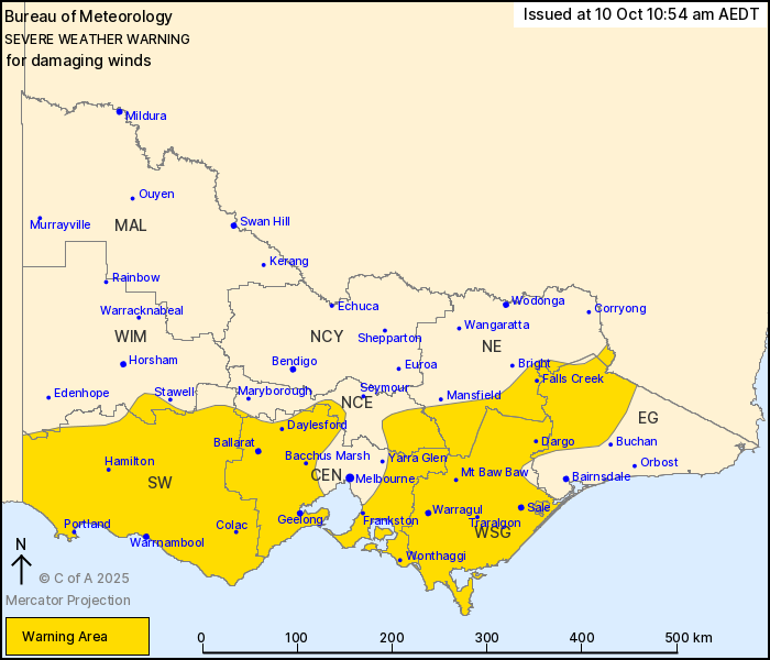
Source: Bureau of Meteorology
For people in Central, South West, West and South Gippsland and
parts of East Gippsland, North Central, North East and Wimmera
Forecast Districts.
Issued at 10:54 am Friday, 10 October 2025.
Damaging winds continuing over southern Victoria today.
Weather Situation: Vigorous west to northwesterly winds are
expected to continue over much of Victoria today as a cold front
currently passing through the South West district moves eastwards
across the State. Elevated and coastal parts are expected to
continue to see the strongest winds, but damaging winds remain
possible elsewhere through the warning area associated with
showers.
For COASTAL PARTS: DAMAGING WINDS averaging 55 to 65 km/h with
peak gusts around 100 km/h are likely today. Winds are expected to
ease in these areas later this evening.
For ELEVATED AND ALPINE PARTS: DAMAGING WINDS averaging 70 to 80
km/h with peak gusts around 110 km/h are likely today. Winds are
expected to ease in these areas later this evening.
For the REMAINDER OF THE WARNING AREA: DAMAGING WIND GUSTS with
peak gusts around 90 km/h are possible today. Winds are expected to
ease in these areas later this afternoon.
Locations which may be affected include Warrnambool, Ballarat,
Geelong, Traralgon, Hamilton, Portland, Wonthaggi, Bacchus Marsh,
Sale, Daylesford, Frankston and Warragul.
Significant wind observations to 10:30 am AEDT include:
100 km/h wind gust was recorded at Mount Gellibrand at 9:50
am.
98 km/h wind gust was recorded at Mount Hotham Airport at 9:47
am.
106 km/h wind gust was recorded at Aireys Inlet at 9:12 am.
120 km/h wind gust was recorded at Mt William (Grampians) at 6:52
am.
106 km/h wind gust was recorded at Mount Buller Airport at 6:07
am.
The State Emergency Service advises that people should:
* If driving conditions are dangerous, safely pull over away from
trees, drains, low-lying areas and floodwater. Avoid travel if
possible.
* Stay safe by avoiding dangerous hazards, such as floodwater,
mud, debris, damaged roads and fallen trees.
* Be aware - heat, fire or recent storms may make trees unstable
and more likely to fall when it's windy or wet.
* Check that loose items, such as outdoor settings, umbrellas and
trampolines are safely secured. Move vehicles under cover or away
from trees.
* Stay indoors and away from windows.
* If outdoors, move to a safe place indoors. Stay away from trees,
drains, gutters, creeks and waterways.
* Stay away from fallen powerlines - always assume they are
live.
* Be aware that in fire affected areas, rainfall run-off into
waterways may contain debris such as ash, soil, trees and rocks.
Heavy rainfall may also increase the potential for landslides and
debris across roads.
* Stay informed: Monitor weather warnings, forecasts and river
levels at the Bureau of Meteorology website, and warnings through
VicEmergency website/app/hotline
10/Oct/2025 12:40 AM


