
Source: Bureau of Meteorology
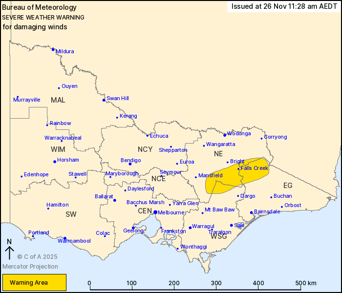
For people in parts of East Gippsland, North East and West and
South Gippsland Forecast Districts.
Issued at 11:28 am Wednesday, 26 November 2025.
Damaging winds about the eastern Alps today.
Weather Situation: Increased west to northwesterly flow associated
with the passage of a cold front today is bringing damaging wind to
elevated areas in the east. Showers and isolated thunderstorms this
morning and afternoon also pose a wind gust risk.
FOR ELEVATED AREAS ABOVE 1400 METRES: DAMAGING WINDS, averaging 60
to 70 km/h with peak gusts in excess of 100 km/h are likely through
this morning and afternoon, before easing by early evening.
Locations which may be affected include Falls Creek, Mt Hotham and
Mt Buller.
94 km/h gust was recorded at Mt hotham at 11:13 am.
102 km/h gust was recorded at Falls Creek at 10:51 am.
The State Emergency Service advises that people should:
* If driving conditions are dangerous, safely pull over away from
trees, drains, low-lying areas and floodwater. Avoid travel if
possible.
* Stay safe by avoiding dangerous hazards, such as floodwater,
mud, debris, damaged roads and fallen trees.
* Be aware - heat, fire or recent storms may make trees unstable
and more likely to fall when it's windy or wet.
* Check that loose items, such as outdoor settings, umbrellas and
trampolines are safely secured. Move vehicles under cover or away
from trees.
* Stay indoors and away from windows.
* If outdoors, move to a safe place indoors. Stay away from trees,
drains, gutters, creeks and waterways.
* Stay away from fallen powerlines - always assume they are
live.
* Be aware that in fire affected areas, rainfall run-off into
waterways may contain debris such as ash, soil, trees and rocks.
Heavy rainfall may also increase the potential for landslides and
debris across roads.
* Stay informed: Monitor weather warnings, forecasts and river
levels at the Bureau of Meteorology website, and warnings through
VicEmergency website/app/hotline.
26/Nov/2025 12:31 AM

