
Source: Bureau of Meteorology
Refer to VicEmergency for AWS alerts
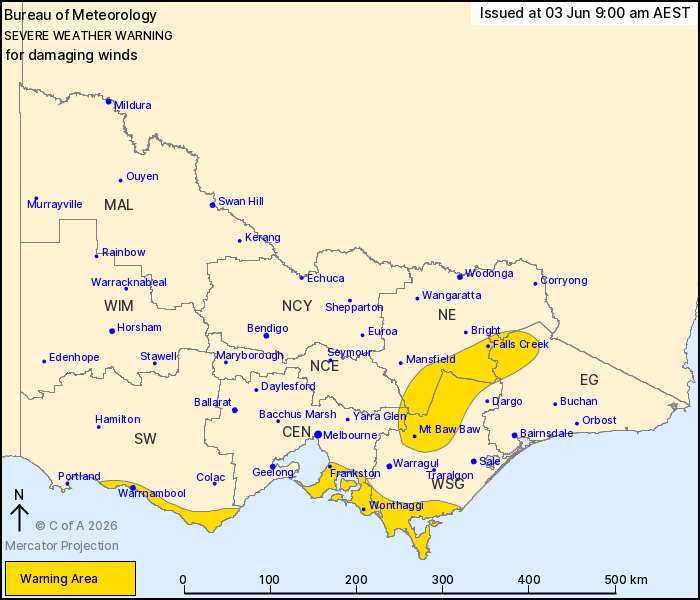
For people in parts of Central, East Gippsland, South West, North
East, West and South Gippsland and North Central Forecast
Districts.
Issued at 9:00 am Wednesday, 3 June 2026.
Damaging winds developing about southern Victoria and the
northeast ranges.
Weather Situation: A deep low pressure system will move through
Bass Strait, leading to an increase in westerly winds over southern
Victoria throughout Wednesday afternoon. This will extend to the
northeast ranges into the evening.
For the Southern Coasts: DAMAGING WINDS averaging 60 to 70 km/h
with DAMAGING WIND GUSTS of around 90 km/h are possible from early
Wednesday afternoon. Winds are forecast to ease from the west
during Wednesday evening and along remaining parts of southern
coasts by Thursday morning.
For the NORTHEAST RANGES: DAMAGING WINDS averaging 60 to 70 km/h
with DAMAGING WIND GUSTS below 100 km/h are possible from late
Wednesday. Winds are forecast to ease during Thursday
morning.
A separate warning for ABNORMALLY HIGH TIDES is also current for
parts of the coast. For more details, refer to
https://www.bom.gov.au/weather-and-climate/warnings-and-alerts
Locations which may be affected include Warrnambool, Wonthaggi,
Frankston, Falls Creek, Mt Baw Baw and Rosebud.
The State Emergency Service advises that people should:
* If driving conditions are dangerous, safely pull over away from
trees, drains, low-lying areas and floodwater. Avoid travel if
possible.
* Stay safe by avoiding dangerous hazards, such as floodwater,
mud, debris, damaged roads and fallen trees.
* Be aware - heat, fire or recent storms may make trees unstable
and more likely to fall when it's windy or wet.
* Check that loose items, such as outdoor settings, umbrellas and
trampolines are safely secured. Move vehicles under cover or away
from trees.
* Stay indoors and away from windows.
* If outdoors, move to a safe place indoors. Stay away from trees,
drains, gutters, creeks and waterways.
* Stay away from fallen powerlines - always assume they are
live.
* Be aware that in fire affected areas, rainfall run-off into
waterways may contain debris such as ash, soil, trees and rocks.
Heavy rainfall may also increase the potential for landslides and
debris across roads.
* Stay informed: Monitor weather warnings, forecasts and river
levels at the Bureau of Meteorology website, and warnings through
VicEmergency website/app/hotline.
02/Jun/2026 11:07 PM

