
Source: Bureau of Meteorology
Issued at 11:30 am AWST on Friday 20 March 2026
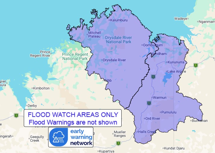
Flood Watch Number: 2
FLOODING POSSIBLE ACROSS PARTS OF THE KIMBERLEY FROM MONDAY
Tropical Cyclone Narelle is currently located over the Cape York
Peninsular and is moving westwards. This system is forecast to
continue westwards across the Northern Territory during the weekend
and into Western Australia around Monday.
Tropical Cyclone Narelle is forecast to bring widespread heavy to
locally intense rainfall to the northeastern parts of the Kimberley
from Monday. Catchments are wet to saturated across the Kimberley,
and rivers and creeks will respond rapidly to heavy rainfall.
River and creek level rises, prolonged overland flooding and
ponding are possible from Monday. Roads may be affected, and some
communities may become isolated. Check road conditions before
travelling.
There remains uncertainty as to the timing and track of the
cyclone. The areas included in the Flood Watch will be refined over
the coming days based on the updated cyclone forecast track.
Catchments likely to be affected include:
North Kimberley Rivers
East Kimberley Rivers
(Flooding more likely in northern parts)
For the latest flood and weather warnings see
www.bom.gov.au/weather-and-climate/warnings-and-alerts
For the latest rainfall and river level information see
www.bom.gov.au/australia/flood
Safety Advice:
Don't drive, walk, swim or play in floodwater because it is
dangerous.
Stay away from flooded drains, rivers, streams and
waterways.
Obey road closure signs. Plan ahead so you don't drive on flooded
roads.
Check the ABC and local media for updates. The situation can
change quickly, so stay informed.
For local emergency management warnings and advice visit
www.emergency.wa.gov.au/.
For emergency assistance call SES on telephone number 132 500. In
life-threatening emergencies, call 000 (triple zero)
immediately.
Rainfall and River
Conditions Map
20/Mar/2026 03:40 AM

