
Source: Bureau of Meteorology
Issued at 10:38 am AWST on Saturday 28 March 2026
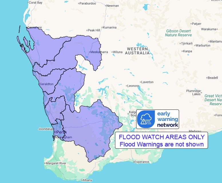
Flood Watch Number: 11
FLOODING POSSIBLE IN SOUTHERN PARTS OF THE GASCOYNE, CENTRAL AND
LOWER WEST CATCHMENTS
Ex-Tropical Cyclone Narelle has weakened during Saturday morning,
becoming a subtropical low which is currently located in the inland
Central West. The system will continue to move rapidly towards the
south southeast during the remainder of Saturday, with the risk of
heavy rainfall continuing as the system passes through the southern
Gascoyne and parts of the South West Land Division.
Catchments are relatively dry across the Flood Watch area. River
and creek level rises and areas of flooding may develop from
Saturday afternoon. Localised flooding and overland inundation is
also possible within the Flood Watch area as well as overland
flooding and ponding.
Roads may be affected, and some communities may become isolated.
Check road conditions before travelling.
Catchments likely to be affected include:
Avon River
Swan River
Moore and Hill Rivers
Yarra Yarra Lakes District
Greenough River
Murchison River
Wooramel River
Flood Warnings are current for the Gascoyne and Lyndon-Minilya
catchments. A Severe Weather Warning is current for parts of the
Flood Watch area.
For the latest flood and weather warnings see
www.bom.gov.au/weather-and-climate/warnings-and-alerts
For the latest rainfall and river level information see
www.bom.gov.au/australia/flood
Safety Advice:
Don't drive, walk, swim or play in floodwater because it is
dangerous.
Stay away from flooded drains, rivers, streams and
waterways.
Obey road closure signs. Plan ahead so you don't drive on flooded
roads.
Check the ABC and local media for updates. The situation can
change quickly, so stay informed.
For local emergency management warnings and advice visit
www.emergency.wa.gov.au/.
For emergency assistance call SES on telephone number 132 500. In
life-threatening emergencies, call 000 (triple zero)
immediately.
Rainfall and River
Conditions Map
28/Mar/2026 02:57 AM

