
Source: Bureau of Meteorology
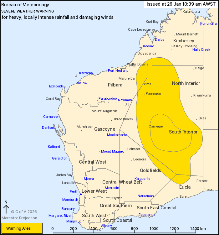
For people in South Interior and parts of Kimberley, Pilbara,
Goldfields, Eucla and North Interior districts.
Issued at 10:39 am Monday, 26 January 2026.
HEAVY RAINFALL AND DAMAGING WINDS CONTINUE AS EX-TROPICAL CYCLONE
LUANA MOVES SOUTH. INTENSE RAINFALL IS POSSIBLE IN THE SOUTH
INTERIOR ON TUESDAY.
Weather Situation: Ex-Tropical Cyclone Luana is moving steadily
towards the south over the next few days. Ongoing severe weather is
likely near the system today in the North Interior and adjacent
parts of the Pilbara and Kimberley. This will extend through the
remainder of the warning area on Tuesday and Wednesday as the
system moves further southwards and combines with an approaching
upper trough.
DAMAGING WIND GUSTS of about 90 km/h are possible near the centre
of the system during Monday and Tuesday, particularly in
thunderstorms.
HEAVY RAINFALL which may lead to FLASH FLOODING is likely about
the Northern Interior, as well as southern parts of the Kimberley
and far eastern Pilbara today before clearing these two districts
later this evening. HEAVY RAINFALL will extend further south during
Tuesday throughout the South Interior, reaching into eastern
Goldfields and northern Eucla in the evening. 6-hourly totals
between 60 and 100 mm are likely with 24-hourly totals between 100
and 150 mm.
Locally INTENSE RAINFALL may develop through central parts of the
South Interior district during Tuesday afternoon and evening, with
6-hour rainfall up to 150 mm and 24 hour rainfall totals
approaching 250 mm possible.
Conditions are likely to clear the North Interior district during
Tuesday and easing over the South Interior by Wednesday
afternoon.
Flood Watches and Warnings are current for the area. For more
information, refer to
https://www.bom.gov.au/weather-and-climate/warnings-and-alerts
Locations which may be affected include Carnegie, Parnngurr,
Telfer and Warburton.
The Department of Fire and Emergency Services advises that people
should:
* If outside find safe shelter away from trees, power lines, storm
water drains and streams.
* Close your curtains and blinds, and stay inside away from
windows.
* Unplug electrical appliances and do not use land line telephones
if there is lightning.
* If boating, swimming or surfing leave the water.
* Be alert and watch for hazards on the road such as fallen power
lines and loose debris.
* Keep away from flooded drains, rivers, streams and
waterways.
* Be careful of fallen trees, damaged buildings and debris.
* Be careful of fallen power lines. They are dangerous and should
always be treated as live.
* Assess your home, car and property for damage.
* If damage has occurred take photos and contact your insurance
company to organise permanent repairs.
* If your home or property has significant damage, like a badly
damaged roof or flooding, call the SES on 132 500.
26/Jan/2026 02:55 AM

